Summer is back! I left home in glorious sunshine and the forecast promised to be good all day. Obviously this isn’t guaranteed, so I packed my waterproofs, I think I must be mentally scarred from the previous two walks. Today was going to be one of my longest train journeys at just over 3.5 hours, if all the connectors work. Although it will be the first time since Kent Day 1, at London Bridge, when the return journey will be shorter. I must be turning towards home. The journey was four trains – Burgess Hill to Three Bridges, to Redhill, to Tonbridge, to Ashford and arriving at Sandwich. All for £18.90, with rail card!

I arrived at Sandwich on schedule at 12:40. I have a long day of around 35km planned so I needed to get a move on. To that end, I took a bit of a short cut from the station which missed out a bit of the older town. I’m sure it would have looked better than the rain drenched view last week, but needs must. I may have gone into town to find a bakers, or even a Sandwich – sandwich bar, but the map didn’t reveal anything like that. Surely a this is a missed business opportunity.

I soon got onto, what looked like, the town wall or moat with views through to the older buildings. While I’m sure Sandwich respects it’s medieval history, I was particularly pleased to see a street named in celebration of David Hasselhof and Kit. Someone even had, what I expect is, the closest modern replica of the original Knight rider.


I was soon out of the town, walking around the marshes on the top of the sea defence bund. I had to walk north for quite a long way to near the mouth of the river Stour, before turning east to the coast. At some points I could see how high the river was, compared to the surrouding land. This area must be at some risk of flooding. It was about 8 km before I reached the actual coast, and could start walking south. It was lovely and quiet, without a single soul about.


The coast here is low sand dunes abutting a shingle beach. It seems this area is perfect for golf courses. I counted at least three courses in the 10 km to the town of Deal. At least one of them is really posh, and occasionally holds the British Open. I think it was the middle course, called The Royal St. George’s Golf Club. What made it stand out was that nearly every player had a caddy to carry the bag, and look for lost balls – it seems that you may not need to be a good player.


The path was good, and I managed to keep up a good speed. I’ve taken to photographing my watch every hour, to help me stay on target and to avoid issues with occasionally straying into the Central European time zone. I really needed to keep the pace up on the first three quarters of the route, as it was dead flat while the final quarter has some climbing where it kicks up (and down) onto the White Cliffs of Dover.


The town of Deal looks like a really nice place (I think I say that about everywhere – I hope that doesn’t devalue my recommendations) with rows of nice old buildings facing directly out over a completely undeveloped sea front.


I had to deviate inland slightly to get to Al’s Bakery. I was a bit late, at 3:30, so I didn’t get the best choices, although I’m not complaining at two, very good, sausage rolls and a custard tart. My favourite!


I was soon back out on the coast, just knowing there was a custard tart in my rucksack gave extra power. It was a well developed path with green lawns and lovely original sea side homes, including some mansions. I could see the path rising ahead and knew the hard bit was coming.


The worst bit was the initial flight of randomly spaced rock steps. After 25 km in my legs, these were a struggle, but as soon as the path became just slopes I was rather surprised to find I was fine. Going down wasn’t quite so nice, but actually my tired legs got used to it. The views were fantastic and the benefits of being high up were definitely worth a bit of hard work.


The ferries going in and out of Dover were much closer, but not as close as you may think as at every high point there was another dip and climb hiding Dover. A main feature was the South Foreland Lighthouse, which looks very similar to the North Foreland Lighthouse I saw on my last walk. They must have marked the north and south kent coast line.


From the Lighthouse onwards the path is really well constructed and contours around some of the bigger drops. Even on a quiet Tuesday afternoon there were quiet a few people out and about, and the path (trying to) keep people away from the cliff edge.


On my map, some “sound mirrors” were marked. These are early attempts at radar, and just amplifying the sound of approaching enemy aircraft in WW2. I was hoping for a good look, but they were located in the cliff below the coast path. There are some more further along the coast at Denge, and I’ll try to get a look at them in the future.


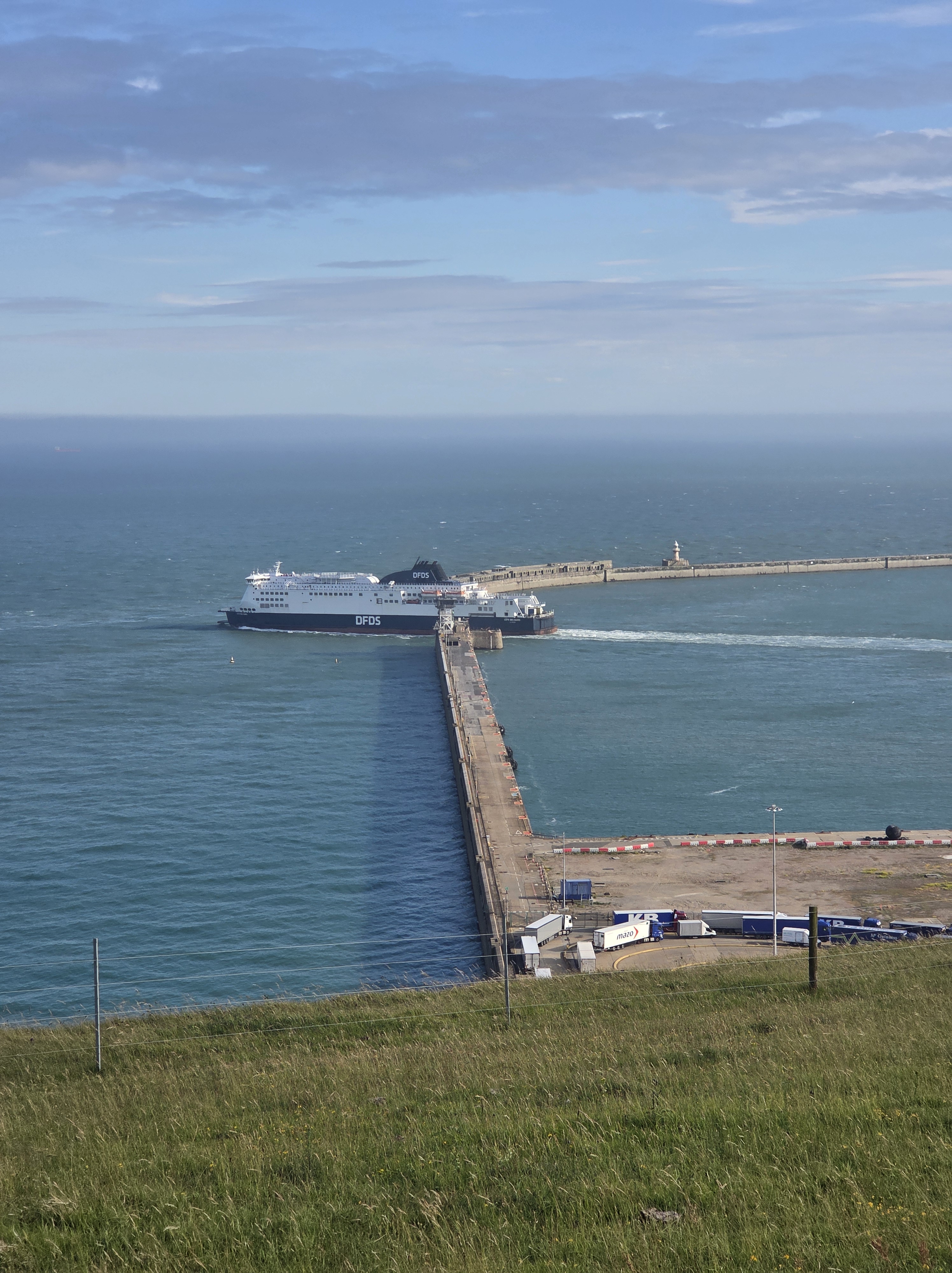
I walked past a jumper that had been dropped on the path, and then immediately turned back, struggled to bend over and hung it on the fence so other people wouldn’t walk on it. I found the owner just before Dover. She said it was her favourite sweater, and was prepared to walk back 2.5 km to pick it up. Strangely I was pretty much able to pin point the location on the map so she knew how far to walk. Good luck – I would have left it! The last few kilometres into Dover gave marvellous high level views over the Port. There is so much going on. There was no sign of the Sailink boat – surely the only way to cross the channel – and here is another link – saillink.co.uk

Finally the path dropped down into the town. Initally along very old streets of houses squeezed into the bottom of the cliff face, and then onto busy urban dual carriageways carrying the cross channel traffic.

I think I had plotted a more scenic route, but time was getting on and I decided to take a straight line route to the station. There were good views of the castle, which despite walking right past, you don’t see at all from the cosast path. I got to the station by 7, in time for the 19:18 train. I was really pleased I kept up a good pace, as even this train will not see me home before 10:30. The journey home was improved significantly when I found the custard tart had survived unscathed in the bottom of my rucksack. This has been another good section – a fine day out.


I have two days left to finish Kent, and get back to Rye where I started my Sussex Coast Path quest. When completed, it will mean I have walked from London to Devon – the long way! I think the last two days need to be done together as there are no (or limited) transport links in this last quadrant of Kent.


