What a difference to last week. I left the house in glorious sunshine, although I think I will still get wet as showers are forecast. Today should be the last time I need to use the tortuous “not via London” route (although my cheat using the bus helps make this easier) as I’ll be heading around North Foreland, which is the most easterly point of Kent, and walking south. This should mean I can start catching trains that go through Tonbridge and Sevenoaks. That said, I think it will only be for two journeys as there are, hopefully, only three days of Kent left, after today. Speaking of the bus, it always passes a stop called “The Chinese Garage”, which I’ve never got a good look at, due to steamed up windows or being sat on the wrong side. Today I was right up the front on a clear day, hoping for a glimpse of some MGs and BYD cars*. Unfortunately it was only a nice Chinese building, that doesn’t seem to be a garage anymore- maybe a Majestic Wine Warehouse. *these were the only Chinese brands I could think of, but apparently Chinese cars account for over 10% of sales in the UK, there are up to 26 Chinese car brands – some like Chery having multiple sub-brands like Jaecoo and Omoda.

I had a few minutes to spare in Bromley so decided to walk around the corner to a strange sculpture that the bus had passed. It is sort of an elephant-tuba riding a small tricycle. As I was taking a picture a woman came up and told me how much of a waste of money it had been (£20k apparently). I said how much I liked it and have come a long way to see it (well, just around the corner). This seemed to infuriate her and she started a rant about her being a fine art artist – I suspect she may have been a p*ss artist! Anyway, it was interesting to see how public art can get a conversation going and proving that it was definitely worth the money.

On the train approaching the North Kent Coast the sun disappeared and as expected, the rain started. Just before Margate, the sun came out again. I’m pretty sure that when I got off the train it was sunny on the platform. However, by the time I’d taken a few photos of the booking hall, it was raining outside. I was much better prepared than last week. I’m not going to forget the hailstones stinging my calves, for a long time! I’d already put the waterproof rucksack cover on, and put my (better than last week) coat on as I left the station. After another 50 metres it was clear it was pretty serious rain, so out came the over trousers, and after another 50 metres my cap came out, and I was ready for any weather. The big tower, which I now know is Arlington House after listening to Mark Steel, looked fantastic, it takes drab to a completely new level. This drabness, is perfectly balanced by the colour of the sand, which looks suspiciously like it has been delivered by Travis Perkins over the winter.


My only real memory of Margate, was coming here on a secondary school trip from Sutton. We came on a (maybe a special) train for the whole school. The train was one of the old slam door trains, and as we pulled into the station someone (it might have been me) had opened the door catch (I think it was one of those where you had to put your hand out of the window to open from the outside). There was a big shove from the back and two or three of us ended up rolling down the platform. We did get in trouble, although the real perpetrator (the “shover”) got away scot free. Anyway, all I remember is that, and the Dreamland fair ground. Which does seem to still exist, but I’m not sure if it is still open. Or maybe this was all a dream, it does seem a long time ago, anyone remember?

Carrying on into the town, I’d identified a bakers on the map, but failed to find it in real life. It is going to be quite an urban walk, with a few towns so I didn’t mess around too much. The path passed right by Margate’s Turner Contemporary Art Gallery. There was a big sign saying it was free, and it certainly looked dry, so I treated myself to a 5 minute ” gallery dash”. It looks good, and I didn’t do it justice but I did see the Turner, and the big painted window looking out to sea was excellent.


The rain had subsided when I came out, and I headed off on the concrete promenade below the low cliffs. The path alternated between the top and the bottom of the cliffs. Often signage sent you to the top, but I was then looking down on people I’d just passed walking along the bottom. I Guess you just need to be in the know.


When the sun was out, it was a glorious walk past lots of little sandy bays, occasional chalk stacks, military defences and Kingsgate Castle. Kingsgate Castle looks pretty fancy, and is located on (what I would have thought) the strategically important most easterly point of Kent. Actually, it is a faux castle built as a stable, rather unbelievably according to Wikipedia. Although it does say that it was redeveloped into a stately home, and more recently a hotel. Kingsgate does seem to have a historic importance with a number of Kings landing here, hence the name. Presumably it was pretty convenient point to stop on the way from the continent.
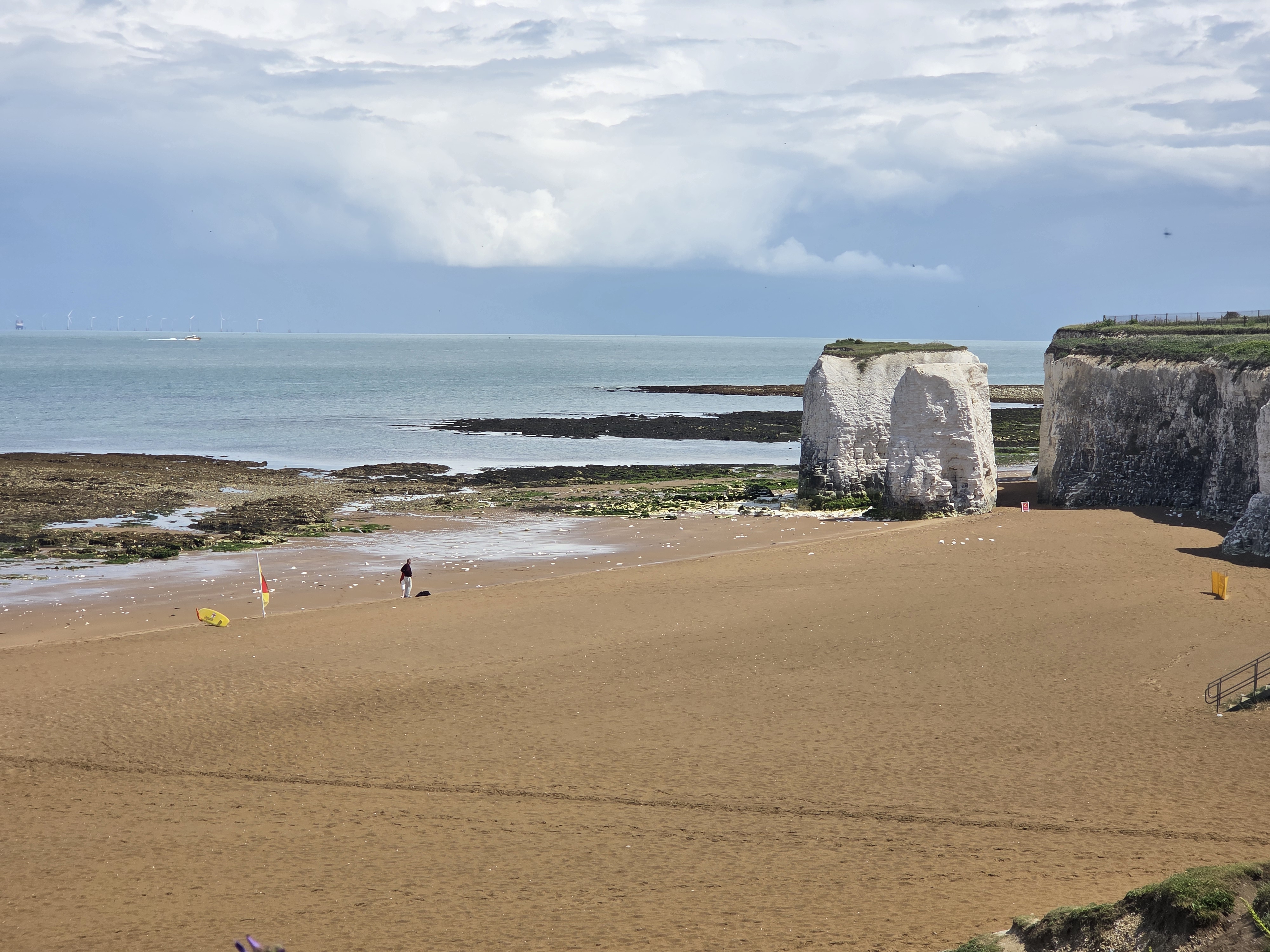

I’m heading south now, it feels like I have broken the back of Kent – but 14 days from London, its a big county. The lighthouse at North Foreland marks the point. There were a lot of fancy houses on the coast in this area, at one point the path was diverted inland, so the really fancy houses didn’t have to have the hoi polloi walking past. I realised how fancy this estate was when there were automatic barriers keeping cars out. I’m not sure how they work, maybe AI assessing whether its a Rolls Royce, or do you press a buzzer and ask for Mrs Fortescue-Smythe?


Once on the public road, the grand houses continued but they seemed to have been built in the grounds of really old mansions. Its quite an area. I took a small footpath which turned into a narrow gully down to the beach. I could hear rain, but the foliage and the gully kept me dry.


Once on the beach, the rain really started and I first put my coat on, and decided it was bad enough for over trousers. It was, it poured down. Walking up the steep roads into Broadstairs, against the volume of water pouring down the roads towards the sea. Its been a wet walk, but if you have the right gear its not too bad. I had one minor scare, when I thought I had somehow lost an hour of walking. I try to strictly keep to walking 10 km every two hours (walking 5 km in one hour is completely different- and would gimme you any time to catch up from stops, or art galleries). So when I found my watch saying it was 3:30 and I’d only walked 10 km, I thought I must have been ambling along day dreaming or something. It made no sense. After a while my phone pinged, to give me “rate advice” and it became clear. My phone had connected to France and my watch had changed. It was a bit of a relief as I was going to have a long day anyway, and an extra hour might mean I can’t get home.

I was looking for a bakers, or even just a shop, for some food, but the weather wasn’t conducive for wandering around. I pushed on to a seaside shelter, which was full of jolly holidaymakers with fishing nets and everything. I found a seat and tucked into my emergency Greggs sausage roll. I may not have mentioned this before, but never-ever start a long walk without an emergency Greggs sausage roll in the bottom of your rucksack! The rain started to ease up, so I headed off again soon dropping back down to the beach level. The view had started to change, and I think I could see Dover on the horizon (In fact, I think it is actually Deal, which is almost Dover).


At the strangely/aptly (?) named Dumpton, I climbed up “Dumpton Gap” back onto the cliff top. From here the path took a rather pleasant route, occasionally through woods, towards Ramsgate. Obviously what goes up, must come down, so I had to tackle a steep set of winding stairs down to the promenade into Ramsgate. There wasn’t too much to see, but some of the graffiti was humorous.

I started to wonder whether I should have stayed on the high level when looking at the map, and climbing a set of stairs didn’t look too appealing, but when I passed the Ramsgate tunnels I knew I was in the right place.

From my career, Ramsgate and more generally Isle of Thanet, is famous for tunnels. The geology of Ramsgate is chalk, and as such very easy to dig tunnels through. The current Ramsgate Tunnels museum is for rail tunnels, where a number of companies were just too keen to build railways right to the coast. On a couple of occasions, trains ran out of control in the steep tunnels and crashing out onto the beach. This resulted in their closure. On the drainage side, it was just too easy to dig tunnels to put the sewers in, there was also an excess of miners, and therefore pipes were put everywhere. This has led to so many problems as the pipes can leak, and access is almost impossible. I worked on a number of projects over the years trying to solve this, but it is pretty much un-solveable.

The rain started again as I reached Ramsgate harbour. There was no obvious shop for a decent sandwich, or pasty (but given my destination a sandwich seemed more appropriate), so I grabbed some crisps and chocolate in a sweet shop. It would have to do. Ramsgate has some very fancy buildings in dark red brickwork and the harbour housed some nice boats, including what looked like a Spanish ship, maybe from the Armada.


The route followed the roads and gradually rose up above the yachting harbour, and then looking down on the commercial harbour. I used to have cross channel ferries (going to Dunkirk if I remember correctly) but it doesn’t look very used now. It looks to be mainly caravan storage which I wouldn’t have thought was the most ideal place to store a caravan.


The coast path left the road, and followed the cliffs through well kept lawns and gardens. It was head down as dark clouds started building, and I could hear distant thunder. For the third time today I had to put my waterproof trousers on. The weather was about to turn even worse. Torrential rain, hail, thunder and lightning. It seemed I was between two storms, there was one out to sea, where I could see lightning, and another storm was on my right over the land. The thunder never stopped, and I had a great view of the lightning forking down to the sea.


I walked down the roads to Pegwell Bay, it would have been quicker to get down swimming. The water in the roads was so fast and deep, if you had to cross the flow you wondered whether your foot might get washed away.


The coast path left the roads and headed along small footpaths. It was nice to be back in the countryside but some of the puddles on the path were pretty large. You can’t get wetter than wet, so I just splashed through. On the map I had spotted a Viking Longship. I don’t know what I was expecting, but I was a bit disappointed.


From here, with the rain getting lighter, the official coast path just follows roads. There was a slight diversion into Pegwell Bay Country Park, which gave good views over the estuary of the River Stour, and a changing landscape of flatter, sandy marsh. But it was soon back on the roads. The worst bit was on the cycle path next to a 50 mph dual carriageway. While roads are noisy at the best of times, wet roads are even noisier, together with big plumes of spray. I had a 3 km stretch, a good opportunity to get my speed up. With tired legs I maintained 9:45 per km, which isn’t too bad.


After turning off the dual carriageway, I was still following the roads which, while quieter were narrower, and gave the issue of being splashed. I armed myself with some pine cones ready to strike back at any car that splashed me. I escaped unscathed and made it over the narrow bridge into Sandwich. It was a short walk through the quaint “olde worlde” streets to the station, and quite a long journey home via Ashford, Tonbridge, Redhill, Gatwick and then home. I think I’m approaching the limits of single day walking, but the sub £19 return fare is just too tempting. The one benefit is I get longer to write all this rubbish!


I think Dreamland is functioning again. Margate’s being gentrified. Maybe thanks to Tracey Emin.
I don’t think the Vasa museum will be too sorry they don’t have that ‘viking’ ship.
What a shame you’ve had such rotten weather. It’s good that it hasn’t put you off
It’s good to see the Gormley people are still around.
Thanks for all the photos.
One last plea: it’s = it is; would have not would of
LikeLike
Cheers Joyce – I thought I’d got out of the would have/of habit – I do know!!!
LikeLike