I didn’t sleep too badly, despite the air conditioning keeping the temperature to a very pleasant, and even quite chilly, 19°C. It reminded me of working in the Middle East! Breakfast was also a reminder of being away, with a group of work colleagues getting ready for some training they were going to give. We are usually trying to work out where we need to go, and when, and whether a car is picking us up. That said, the workers were quite late to breakfast, as I had beaten them and was down before 7 am. I have a long way to walk, and will need every minute.

After checking out, I found the proper way out of the hotel grounds. Arriving yesterday I clambered down a grass bank and had to ask a gardener where reception was. Walking through the car park gave me a feel of the type of other customers at the hotel! I was on my way just after 7:30, that must be some sort of record.

After a few steps and I was onto the sea front, and straight away passed the snack bar where I was attacked by a seagull on my cycling trip. I was starting to get my bearings, as every concrete promenade looks much like the rest. There was to be a lot of concrete, and tarmac today, but before that started, the route headed inland along the Royal Military Canal. It was glorious in the quiet morning, the birds were singing (and fighting), there were dozens of butterflies and next to no people. It was glorious. The still water, and the slightly distorted reflections of the trees made me smile, and I did contemplate making a recording of the birds, like I did in the Peruvian Manu rain forest.


It all has to end, and this happened as I crossed the tracks of the Romney, Hythe and Dymchurch Railway and I was plunged into suburbia. I caught one glimpse of the train, a miniature passenger carrying steam train, later in the day, but I was most surprised to see it went all the way to Dungeness.


A quick stop at a petrol station to buy some emergency lunch. I think I must have known how hard the day would be, as I bought a tin of Irn-Bru. From this point, the day would either be on concrete sea wall, on roads circumnavigating MoD firing ranges, or for the last 15 km on cycle paths (that I had cycled in May, so pretty much knew what was coming). On the positive side, there were absolutely no hills (Strava recorded 90 m of ascent in 50 km, and I’m surprised it was that much). I think I knew it wouldn’t be too exciting, which is why I planned a monster day to get it over with. That said, there were some highlights (apart from the Canal).


The main highlight was Dungeness. The nuclear power stations had been on the horizon since I arrived in Dover. They just got larger and larger. Before I got there, I was very pleased to hear gunfire from the Dymchurch Firing Range. I has been quiet when I’d passed it, and I was thinking I could have sneaked along the beach. The gunfire justified sticking to the rules!

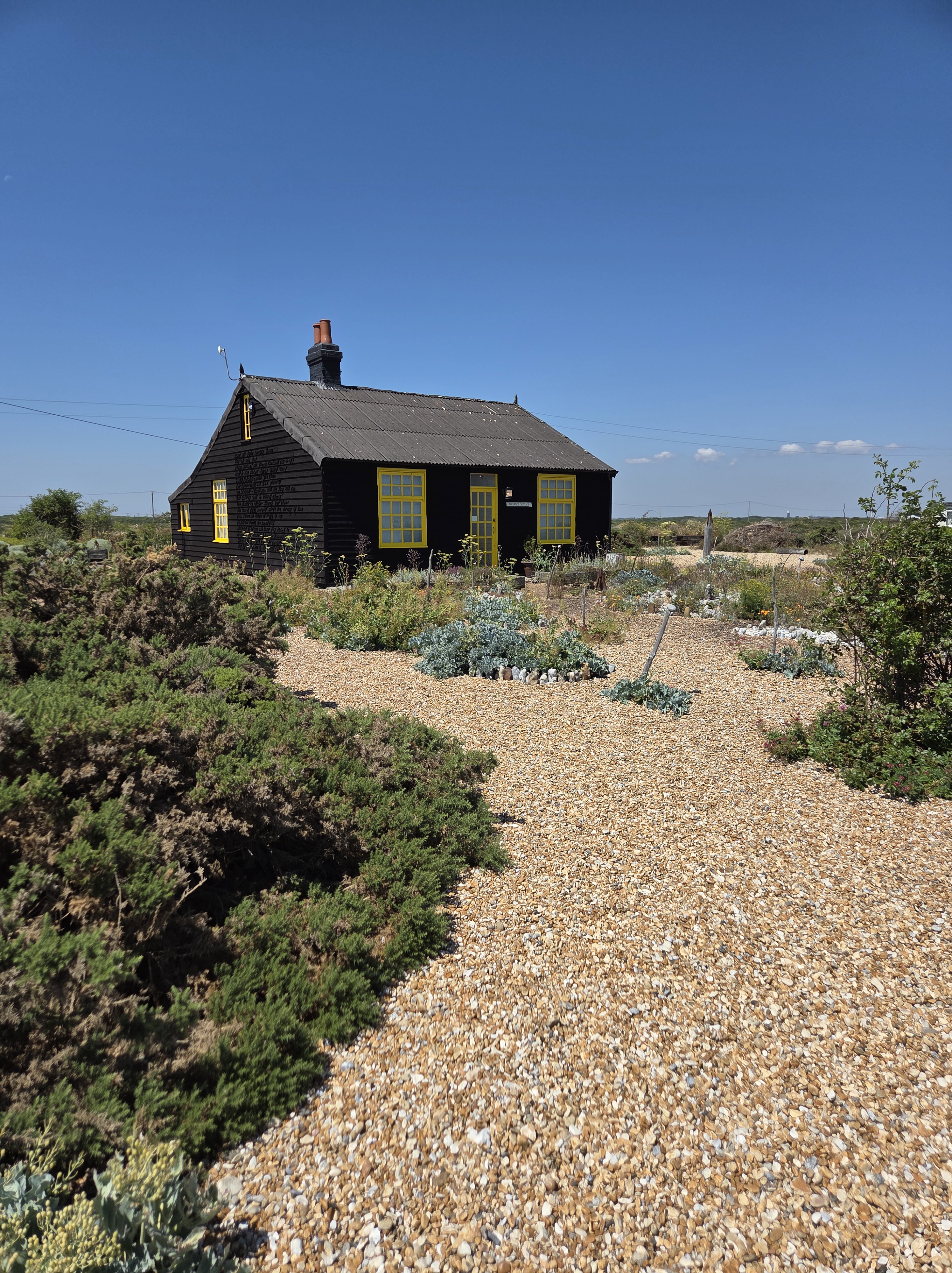
After many roads which cut through the endless shingle beaches, I reached Dungeness. If you ignore the looming power station, it is actually quite easy, the array of tiny huts and homes spread over the shingle moonscape are amazing. Many/most seem to be lived in.


The most famous cottage is Prospect Cottage which belonged to the film director (and much, much more) Derek Jarman. He died in 1994, but the cottage and garden have been preserved. I have been inside many years ago and must visit again – but no time today.

I was at about half distance and started to look at lunch opportunities, anything to avoid my petrol station sandwich. I initially looked in the Fish Hut, which seemed pretty busy but was just a snack van serving people sat outside. It seemed popular with ageing motorcyclists, so I should have been at home, but it all looked a bit false and artificial. I pushed on to the Britannia Tavern. Ignoring the very plain outside, it was a proper pub inside and not too busy. It had been a hot day, and I think the heat had affected my brain when I ordered a Smoked Mackerel Salad. I’m a great believer in your subconscious knowing what is right for you, and in this case my subconscious was spot on. A massive plate of simple salad, with two mackerel fillets. Perfect for a hot day, with a bitter shandy and served really quickly. The other place was so fake, and this was so genuine.


After skirting around the lighthouse, which was surrounded by magnificent lighthouse keeper buildings, there was no more ignoring the Power Station. The path followed the narrow foreshore between the high security fencing and the sea (well the high shingle bank). There were signs everywhere saying it was protected under the Nuclear Installation Act. Incidentally, as I was walking along the (long) road to Dungeness a black unmarked Range Rover when hurtling towards the power station with sirens and blue lights ablaze. There are special Nuclear Police and I was half expecting there to be some incident when I got there. In reality it was probably some kid who had pocketed a fridge magnet in Prospect Cottage gift shop. There are two power stations here, the first I passed was “Dungeness A” which operated between 1965 and 2006, the radio active fuel was removed by 2012 and is now being decommissioned, and “Dungeness B” operating from 1983 to 2021, and the fuel is currently being removed. It is not proposed to build a “Dungeness C” and the eventually the existing buildings will be demolished. From what I have read this could take many decades, “late into the 21st century” is quite a vague programme target! So it could be over 100 years from start to finish, you can see why focus is moving to Small Modular Reactors (SMR) for future nuclear generation.


The fence continued, and the path got narrower, until I had passed the two power stations. There is a third, newer, building which I can’t find out what it is for. Googling suggests its either a new administration building for the demolition, or something to do with cross channel cables, as it had a similar look to the buildings on the Isle of Grain an there is plenty of, presumably, transmission lines with both power stations decommissioned. I couldn’t find a good answer, but the transmission lines leading away from Dungeness are fizzing with something. On the subject of cross channel cables, earlier just before Dungeness, I passed a house with a plaque identifying it as the “Officers Quarters Pluto Pump House 1944”. Pluto means “Pipe line under the ocean” and these were laid quickly after D-Day to provide fuel to the troops liberating Europe. I’ve seen another one on the Isle of Wight. The scale of the ingenuity and planning during war does amaze me.


Having complained about walking on concrete and roads, I was due a bit of light relief. This came in the form of about one km of shingle beach. It was the really tiny shingle that is really hard and exhausting to walk on. Just what I needed at about 30 km into an already long day. I won’t complain too much, as what was to come was worse. At the end of the shingle, Lydd Firing Ranges started together with a really long diversion inland. I don’t think I’ve mentioned that today was during a heatwave, with temperatures exceeding 30 degrees C, and walking on a dusty track between wire fences with a bit of rubbish blowing around really reminded me of doing site visits in the Middle East. It was slightly better, as there was some greenery and birds singing, but it was hard walking. The track became a small road, and the Coast Path seemed to head off on a pointless loop rather than take the direct line. I was so tempted to take the shorter route, but thought the path might be more interesting than the road. I was wrong, the Coast Path was just another road which was disappointing.


I skirted the Firing Range, and while at the eastern end nothing was happening, as I reached Lydd (whose church tower had been taunting me for miles across the flat marshes) the west end seemed to have complete villages to for combat training. There was a whole row of windows high above the ground which I expect snipers would be trained at. The sound of gunfire was more prominent as I reached the village, as well as the car park in the barracks full of school minibuses! There was quite a lot of activity, including a big group of children on mountain bikes cycling through the ranges, it looks like the MoD are diversifying.


From Lydd, back to the coast at Camber I just followed the cycleway that I had cycled in the opposite direction a few months ago when I was Heading East. While it is nice, being remote from the road with wild flowers and relatively good views, it is very boring especially as I knew the route pretty well, so there were no surprises. Just before Camber the coast path went up on the sea wall, which meant I was seeing something new. Unfortunately, it was a huge wide concrete promenade, that was baking hot in the sun. It was so bad, I had to resort to my emergency can of Irn-Bru to keep me going.


The wall finished at Camber Sands and, luckily, the path deviated inland slightly. I didn’t fancy walking on the shingle I could see, and the sand I knew that would be coming up. I’d walked about 40 km in a pretty high heat and was getting tired. Even when the path diverted into a little sand, it reduced me to a shuffle. It started to get busy as I crossed the car park into Camber Sands. I hadn’t been able to locate a water tap on OpenStreetMap, but knew there was a toilet block and a nearby shop. The water in the toilets was not drinking water (or so they say – what other kind of water could it be!), but then I noticed lots of people surrounding a drinking fountain.They were just filling any receptacles they could find and using it to rinse sand of their legs and feet. Its only when you are really thirst,waiting in a queue to drink, that you realise how wasteful this is (why didn’t they use the non-drinking water in the toilets!). Writing this has reminded me to add the drinking fountain to the map.It seems to be the only additions I ever make, and earlier in the walk I found a grand historic one not working, I’ll see if I can get that updated.

From Camber, it was back onto the cycle-way. After the concrete and the sand I think I was beginning to warm to the consistency and familiarity of the cycle path. The coast path should have left the cycle-way and headed across a golf course and follow the river into Rye. Unfortunately due to flood defence works, all these footpaths are closed, so I continued to retrace my previous cycle trip back into Rye.

I got into Rye by 6pm, just missing the hourly train at 5:48, and couldn’t decide what to do. Should I eat, just sit down or go for pint. A crowded pub wa unappealing, by when I passed the Cinque Ports pub, with its doors open welcoming me into the cool interior I just could not resist it. A shandy, a packet of peanut and a soft chair that was too close to the ground and all was well with the world. I had waked 49 km, which Strava says was my longest walk, but I’m pretty sure I’ve been over 50 km a couple of times (although I’d not recommend walking that far).


It was a short walk to the station, and it only took two trains to get home and less that two hours, which is quite a bit different to my journey out and five trains to Dover. Although I did have to walk home from Wivelsfield, a nearby station, and to the shop for some dinner – in all my watch said 61,236 steps. While it had been long and hard, it definitely justified hitting it in one go as there are not many places to stay between Hythe and Rye, and there isn’t really too much to hang around an look at. Dungeness is the highlight, which I think says everything really.

So I’ve finished the Kent Coast, which is by far the longest county I’ve tackled so far. From London Bridge to Rye was 460 km and took 16 days. This nicely joins up my walk from London to the Dorset/Devon (Lyme Regis) border, which has been 1,044 km (649 miles) in 39 days. I’m going to carry on with the South Devon Coast (yes it is the only UK county to have two coastlines) next week, so you can look forward to me saying how nice it would be to walk on a concrete promenade, and what I wouldn’t do for a nice flat cycle-way.

 matt's travel & cycling blog