I’m not letting the early failure of my “Heading East” cycling project stop me from advancing around the Kent Coast Path. On the bike front, I’ve bought some new rims, and ordered the spokes (talk about a complicated calculation) and will teach myself how to build wheels. I’m looking for a two, or three, week window in the summer to carry on cycling to the east. Getting back to Kent. Its a big county, this will be the 11th day of walking and I’ve already covered 255 km (158 miles) but I’ve still 175 km to go. The biggest county before that was Hampshire at 197 km. In total, over 33 days, I’ve walked 870 km (540 miles).

I headed off today for my, now traditional, 9:07 train. I had to renew my railcard, which will pay for itself in two trips – today was a return to Chestfield & Swalecliffe (the ticket office tried to sell me a ticket to Chesterfield!) for £18.90, which I do think is a bargain. I also realised where I went wrong on my last trip, two trains are scheduled to leave the same Bromley South platform at 10:57. Last time, I think I just got on the first (and wrong) train due to not paying attention. I arrived in Faversham, just after 11:30 and it looked even better than when I walked through it on my last walk.


There are so many historic buildings and it seems quite a bustling town. First stop was a bakers, and I was spoiled for choice, and I chose Crust based on pasty reviews on Google ;) . I had a choice of a short crust, or a puff pastry pasty. Its not a choice I’ve had before, so I had to seek expert guidance from the staff. I decided on short crust, being more aligned to the traditional recipe. I’ll review the pasty later.


The town really is the Shepherd Neame Brewery town. Checking Wikipedia, it seems that commercial brewing has been carried out on this site since 1573 – over 450 years!!!! Mind boggling.


The path out of town led through some nice lanes of old buildings down to the River with very busy boatyards. The path was blocked by a crane, and the sound (and smell) of welding everywhere. A short diversion took me through the heart of the boatyard and I was surrounded by boats in various levels of decay.


I soon left civilisation behind and was walking on the flood bund. I must admit here to missing out some of the coast path, which circumnavigates an island in between the two rivers into Faversham. I will walk along one side of both rivers, just not both sides. The island (Ham Marshes) is completely flat, with hardly any buildings so I don’t think I’m missing anything. Equally in my defence, the Isle of Sheppey is still on the horizon and I’m still scarred from walking around that. I think Sheppey has featured for at least the last five days walking and I would really like to leave it behind.

The main feature of the first half of the walk was, excellent views over the Swale, towards Sheppey on my left, and the biggest solar farm I have ever seen on my right (all the area shaded pink in the top right of the map above). The Cleeve Hill solar park can provide enough electricity to power 91,000 homes apparently. I wonder whether another 91,000 homes could have been built underneath the acres and acres of solar panel! I’m being a bit unfair, but there is a lot of land that could be utilised underneath the panels. I expect it is just sprayed with industrial strength weedkiller.

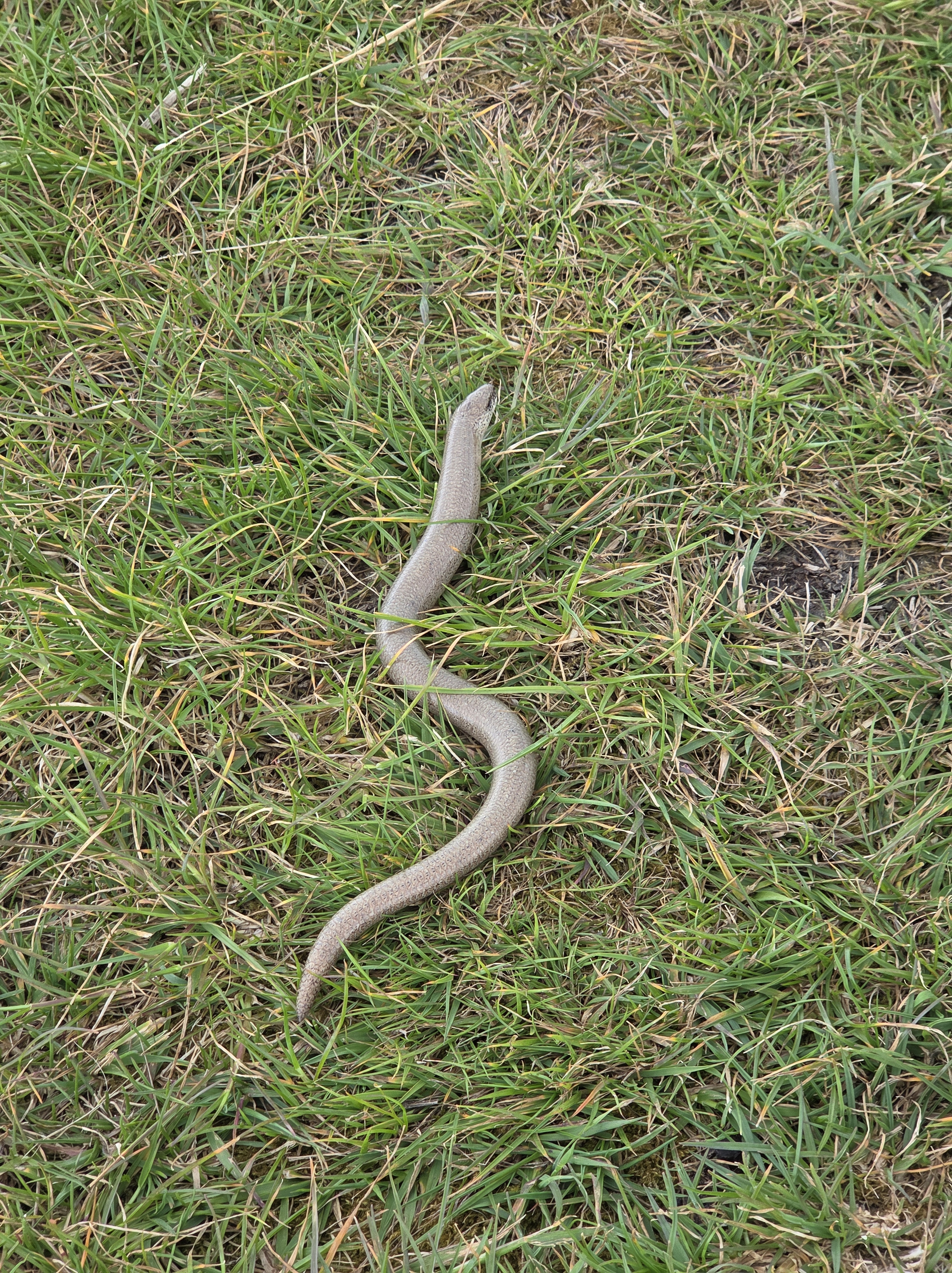
Looking left there was plenty of birdlife, I did break out my binoculars but didn’t see anything too spectacular – a cormorant drying their wings was best. Closer to the path I came across a Slow Worm. It didn’t see phased to see me, and seemed a bit exposed to predators but I just left it blinking in the sunlight.
Talking of the weather, today was a classic, coat on, coat off, no idea what the weather was going to do day. That said, it never rained more than a few drops and my memory says it was generally sunny – but never long enough for a tee shirt. I stopped on a bench to eat my (short crust pastry) pasty, right in line with the end of the Isle of Sheppey, it seemed like a bit of a celebration to have it behind me. The pasty was superb and probably the best tasting North Kent pasty so far. If I had one complaint, it would be that it had a bit too much gravy, and therefore had to be eaten in one sitting. It’s not really a complaint, and probably more of a statement on how dry the others had been.


The first village I reached, after about 10 km which was half distance, was Seasalter. It sounds and looks like it should be in Cornwall, not one hour out of London. It even has a station. The beach front houses are rather swanky, in an overly ostentatious way, but there are one or two really nice gems between the modern “boxes”.


From Seasalter, the development was fairly contiguous with Whitstable. Whitstable looks like a theme park, almost nothing is out of place. Street after street of little cottages and terraces with abundant gardens. Its not such a sight on the outskirts, where presumably all the cleaners live, with miles of shanty town (disguised as beach huts). Even the graffiti was well curated.


The main harbour was closed off for filming, they wouldn’t say what but I expect its the new James Bond after I tipped off in my blog about perfect film locations a few (walking) days ago.

After Whitstable, the coast path returned to following along the sea wall. It went through a few private estates, that based on the fences and big signs, would obviously prefer you weren’t there, but it is nice being nosy at the fancy properties. At Tankerton Beach there are loads of beach huts arranged up the bank. Each was individually painted, and a few were for sale so clearly they are privately owned (rather than being rented/leased of the council). A quick check on Rightmove, £55,000 for a wooden shed with no running water or electricity. The listing’s were vague on the fees to be paid to the council, but I bet there would be more money on top in annual fees!


At the end of the Tankerton promenade, just past Swalecliffe Sewage Treatment works, the Sewage Works is very subtlety hidden behind trees, with just the slightest whiff to let you know its there, From here I turned inland towards the railway.


The path went through a housing estate, which had more than its fair share of ageing Range Rovers’ with number plates beginning in BO55, and then out to Chestfield and Swalecliffe station. Disappointingly, the train I was aiming for was cancelled, giving me an hour wait on a station with no facilities at all. I noticed a drive-thru Costa through the trees and this gave me a target to while away some time.

I was planning on meeting a friend in Dorking for a beer, and this delay set me back a bit. So I used the time to think about different routes. I’d found the “Not via London” restriction on the train a pain, as it involved two trains to get from East Croydon to Bromley South (which are the main hubs on my route). A check of Google maps (forcing it to ignore trains) showed that the SL5 – the TfL SuperLoop bus – went direct from Bromley South to East Croydon in 30 minutes (and every 10 minutes). This is the answer (the SL7 was already my favourite bus from Croydon to Sutton, with only four stops).

I made good time and made it to Dorking, 30 minutes ahead of schedule, the bus is definitely the answer and I can use this route in the mornings on my next few legs which should get me walking earlier. It has been a good day, and I think probably one of the best, in terms of varied landscapes, on the North Kent coast so far.


excellent Matt. Lovely descriptions. Did you have any Whitstable Oysters, they are famous
LikeLike
I didn’t know what a ‘bund’ was and looked it up. A weird word … apparently its root is Hindustani.
Do you ever have chats with fellow travellers?
When you’re typing, does autocorrupt keep giving you apostrophes where they don’t belong?
£55k for a shed is absurd isn’t it.
Great photos again.
LikeLiked by 1 person