It has been quite difficult to sort out today’s logistics, as I needed to catch a bus to the start point and the time table is pretty infrequent during the middle of the day. I bit the bullet and caught a peak train (without railcard discount) but by avoiding “London Terminal” the cost wasn’t too bad at £38. I could do it for under £20 off-peak. It involved a rather tortuous route, leaving Burgess Hill at 07:07, then via Clapham Junction to Denmark Hill on the Windrush Line, and then onto Rochester, changing at Dartford. This has pushed my average daily cost up from £32, but it could have been much worse with the full direct fare being £68. Part of this whole exercise is to show that walking the Coast Path is (largely) achievable using public transport, and that cost shouldn’t be a barrier. Leaving home before 7am, it was bright chilly morning that needed a coat, but the weather forecast promised the warmest day of the year (so far).

On the train up to London, the guard kept making strange announcements between stations. The only one I can remember was that there are more LEGO figures than real people in the world!! [Fact checking this showed it was true, with over 8 billion figures, and another 7 million produced annually to keep the population higher than the human race. This is a bit worrying, do we really need this much pointless extra plastic?]. I arrived in Rochester before 10 am with some time for a walk around. It looks like a really nice city (?, it has a cathedral so I guess it is). It has a really olde world high street, with a rather good bakers that provided breakfast and two Cornish pasties to get me through the day. I need to come back through Rochester on my next section so my food worries can be allayed for that trip.


I caught the 191 bus to Allhallows, which took an hour and was a rather nice journey through some small villges and views across the Thames Estuary. I would spend the day walking back along this route, albeit along the coast and (I hope) not along the road. It seemed like it was going to be a long way. I arrived at Allhallows by 11 am and quickly cut through the caravan park and straight onto the remote coast path.

As soon as I left the caravan park it was clear it was going to be another solitary walk with nobody to be seen for miles. When I was reading about this area (mainly to find where the name “Allhallows” comes from – Hallows means Saint) the Thames Hub Airport was proposed to be built on manmade islands off this coast – you may remember “Boris Island”. It was (is still being?) considered as the location for a Thames Barrage and road crossing to Essex. While this area might not have the prettiest countryside, it is a really remote place, not too far from London and it really should be kept unspoilt. There is already quite enough industrial development on the horizon, I don’t think it needs more.


The Coast Path turned inland slightly and headed towards the huge tanks and structures on the horizon. In the shadow of the industrial area is the village of Grain. It seems to be a tiny village with a small church and a school with kids playing in the playground. It felt like a really remote community (not unlike those I experiences on the Outer Hebrides) yet it is less than an hour to London. The path reached the seafront which felt much more like the proper coast, with an endless horizon. This feeling would be short lived as the path now heads up the River Medway back towards Rochester. Its worth noting here that I have been following signs for both the Coast Path and the Thames Path since the Thames Barrier, but after this point the Thames Path signs have, unsurprisingly, disappeared. Their appearance in the first place is surprising as according to all the information I can find, is that the Thames Path starts at Woolwich, and heads west into the Cotswolds. [It seems in 2022 a “Source to sea” element was added to the Thames Path, which explains it]


The next section was not the best walking on many levels. Initially, I took a footpath (which I thought was a shortcut, but turned out the be on the signposted route) that was completely overgrown, and the beginning section looked to have been intentionally blocked with branches. It was a bit tricky and it left sharp burrs in my clothes that I would continue to find for the rest of the day. They crept into my boots causing a few stops as my socks scratched, and even my arms when I wondered what was scratching me when I put a coat on the walk home from the station at the end of the day.

The next section was along some roads to avoid some major energy sites, which wasn’t great walking, but seeing what is going on in this area was, particularly interesting considering the Iran War and the blockage around the Straights of Hormuz. There is a huge construction site for ConnectNEU which is an electricity converter station being built to connect the German electricity grid to the UK. It is the end of a 720 km which can transmit electricity in either direction and power up to 1.5 million homes. After seeing the wind turbines in Shetland, that were not operating due to a lack of demand, schemes like this would seem essential for distributing excess wind or solar power between different regions. The internet tells me there is already a site called BritNed operating nearby, linking Grain to the Netherlands with a 260 km cable. As well as these electricity sites there is the Grain LNG site, which is Europe’s largest liquefied natural gas terminal receiving tankers of LNG (when they are not trapped in the Gulf!) and putting it into supply or generating electricity through a gas fired power station. These are all quite new energy sources and replace an Oil Refinery which was decommissioned in 1982, although tanks still remain and the Kingsnorth coal fired power station which was closed in 2010.

The road section was short lived, and the path soon returned to the remoteness of the Medway Estuary, with lots of bird life and the industry disappearing into the distance. The walking was slightly tricky as the path followed the top of a berm which had been well trod by, presumably, cows. There was no sight of the cows, but the mud had dried into a surface that was difficult to walk on. I guess it was easier than actual mud, so I probably shouldn’t complain, however after 15 km in my legs, it was a bit of a struggle.


I passed the “Stoke Airfield” which looked to be located in the most inappropriate location, on a narrow strip of land between the sea and (seemingly right under) some high voltage overhead cables. It seemed to be completely deserted but suddenly I was treated to a microlight coming into land. Somehow it avoided crashing into the cables, pylons or into the sea. I guess the pilot was lucky this time!


The path headed inland from here, essentially to bypass the Kingsnorth Power station site, and it was nice to climb a few gentle hills into the surrounding farmland, before dropping back down to the estuary.

The signage on the coast path now includes the “Saxon Shore Way” path, which apparently starts in Gravesend and ends in Hastings. I haven’t seen much evidence of it on my route, and I think this is because the path follows the original shore line (in Saxon times). This shore line would have been much further inland before the marshes that I has been walking around were reclaimed from the sea. I expect I will be seeing many more signs for it on my way to Rye (as I’ve already walked from Rye to Hastings). This area was much more nautical, with a graveyard of wooden boats slowly being eroded by the sea. It make you wonder how long it takes for them to disappear completely.


After walking through a few marinas, some for yachts, but others with a real mismatch of residential boats, from converted lightships to huge converted ships and barges, the path ended up on the beach. I haven’t bothered to check the tide tables for any of the Kent section, but I think I need to start as this would have been impassable at high tide. It was fairly hard work at a low tide, with some deep mud and treacherously slippery pebbles on the damp foreshore. It was nice to be reminded of some of the Hampshire sections which were like this after so much dedicated path. I think I need to start paying attention to the route with respect to the tides again.


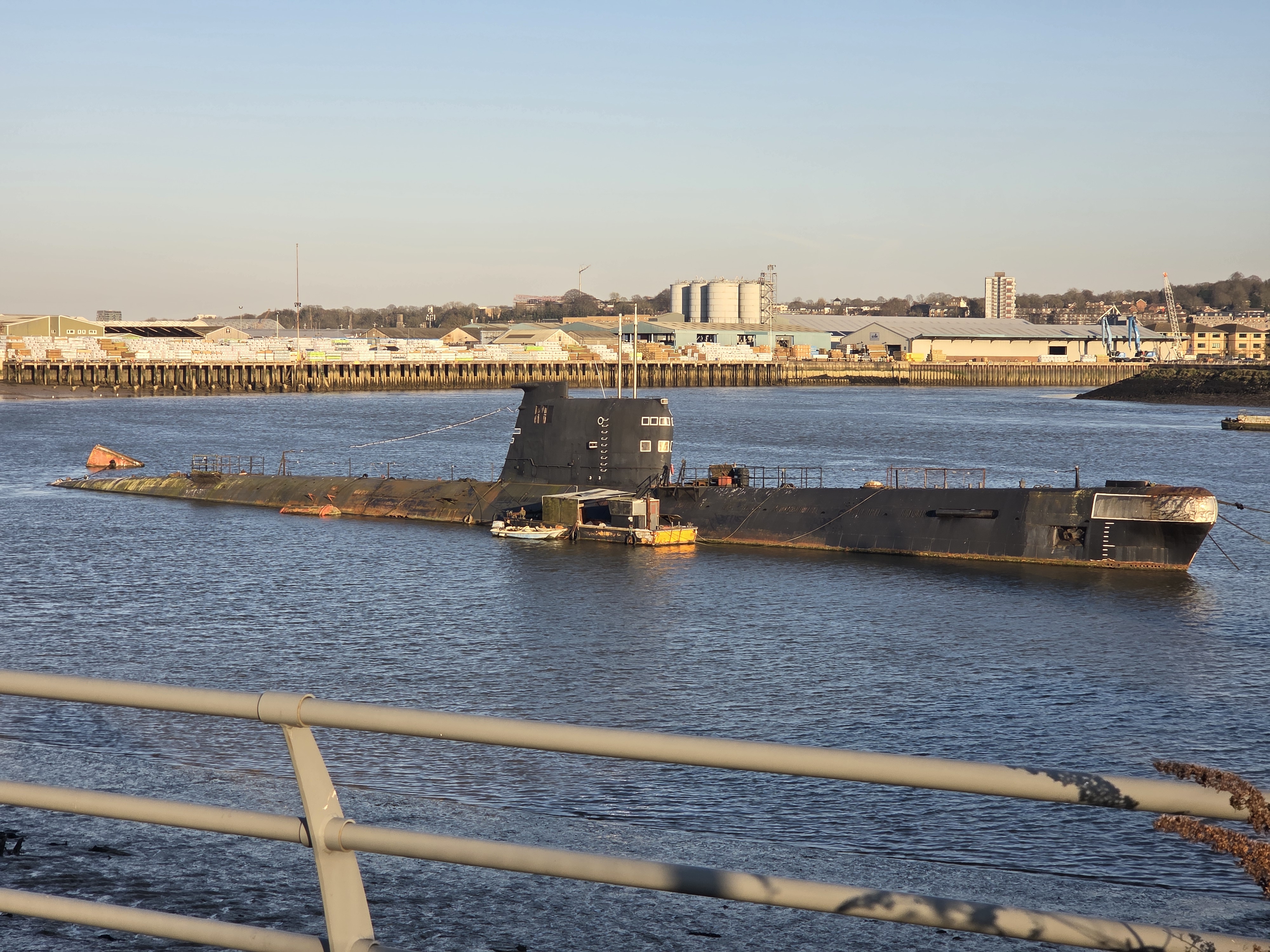
I was reaching civilisation at the edge of Rochester and the River Medway. The path went past quite a few really nice looking riverside pubs, and historic looking naval yards and warehouses. The route diverted inland to pass some of these, which involved some long sets of stairs, which were hard work on my legs. I think at this point I changed my target for the day from Rochester Station, to Strood Station, which would save a few kilometres and crossing the Medway. The one benefit of climbing the hill, was the view from the top, with Rochester Cathedral and Castle across the river, and a submarine!


The submarine is a Soviet Sub dating from the late 1960’s, and had been a museum ship near the Thames Barrier and Folkestone, until 2004. Its been sitting here ever since, gradually rotting away. Its called U-475 Black Widow, and googling it, some of the facts and figures are striking. The thought that seventy men could be onboard such a small craft, that it has a range of 37,000 km (which is almost the circumference of the earth), and that it could remain submerged for up to five days. I’m sort of fascinated by submarines (I may have to visit the museum I saw in Gosport) but the thought of going in one is terrifying.
I made it to Strood Station just after 5pm and I did feel like I’ve had a full day out. Although it had been a beautiful sunny day, I think the early start, and over 30 km in a day maybe just about far enough! Luckily I had saved a Cornish pasty, which boosted me ready for the long journey home (avoiding “London Terminals” obviously!).


Great photos as always. Quite a record. Something King C should read.
Interesting about the major energy sites and what’s going on.
The bakery was a great find wasn’t it. There used to be a good bakery in Seaford; depending on what I wanted to buy, it was either called The Bread Shop or The Cake Shop.
(Its = possession; It’s = it is)
LikeLike
Or The Pasty Shop 😀
LikeLike
To continue the King C theme, as of this walk you are really on the King Charles III England Coast Path National Trail!
Roger Orkney
LikeLiked by 1 person
Hi Roger – it’s been “bigged up” by the press over the last few days – but it is not quite as joined up as they suggest. I’m having to find my own way some of the time.
LikeLike