When I left home today, I didn’t really know what walk I was going to do. Obviously I was going to start in Emsworth, my last finishing point, but where to walk to was a dilemma. My choices seemed to be, 1) walk towards Portsmouth but ignore Hayling Island. The path generally follows the busy A27 through lots of industrial areas. It’s boring and I’ve cycled the route many times. 2) Walk down Hayling Island, and take a ferry across to Portsmouth. I know this is much more scenic, as I walked it on the third day of my Camino. I’m happy with the principle of taking ferries (across estuaries) but in this case could be considered as a shortcut. Or 3) circumnavigate Hayling Island and then do 1) above. This would be the purists choice, and was my main thinking, even though there are very poor, disjointed footpaths on the Eastern side of the island and I calculated it was nearly 40km all in. This could be shortened, but would be a comprise from the purist approach. I really couldn’t decide, even over second breakfast in Hove, where I had a bit of a wait between trains.

In the end, the decision was easy. On the train to Emsworth the rain started and it got pretty heavy at some points. By the time I got out of the station, I had changed into full wet weather gear, with the exception of waterproof trousers. This would prove to be a big error as I got pretty wet very quickly, and it was too late to put them on. I took a slightly different route through town to my starting point. This let me get a view of the other side of the Mill Ponds, and most importantly allowed me to get suitably wet and cold. I had decided, I would walk down Hayling Island and get the ferry across to the mainland, it wasn’t a day for being a purist.

The tide was much higher than when we finished last week, in fact I’m pretty sure we walked along the beach to get here, and there was no beach today. It was pretty bleak walking along the sea wall. I could only think of the classic “Comic Strip Presents” episode where Robbie Coltrane walks along a breakwater to the backing music of Two Tribes by Frankie Goes To Hollywood, epic and I did get splashed once or twice.

That was probably the biggest thing about today, my imagination running wild, as walking in the rain with my hood up means I feel a bit isolated from the outside world and with music like Two Tribes playing in my head. That said the next section was great, following a good path on a low sea wall, and dropping onto the beach just at the right time, in terms of the tide going out. It would have been a bit of a diversion maybe half an hour earlier.

The path headed away from the coast across incredibly muddy fields, the rain had subsided a bit, and there was blue sky on the horizon, but the runoff from the fields showed how much rain there had been. Interestingly, the path went past the isolated St Thomas’ church which seems to be surround by a very large cemetery. It seemed a bit strange in such a remote location. The town of Havant is close by, but it still seemed a bit extreme. So for this blog I thought I’d ask Google, and it came up with a most strange AI response. “Warblington cemetery is considered large primarily due to its historical context as a rural area prone to body snatching in the past, which resulted in the need for a large churchyard to deter grave robbers, with the presence of “grave-watcher huts” still visible within the cemetery grounds today; this large area was necessary to monitor such activity effectively.“. Well you live and learn!


After crossing a very muddy field, full of attack geese, I got back to the coast and views of Hayling Island appearing through the murk. The Ordnance Survey map shows a bridleway crossing the estuary next to the bridge, and while I can accept that the tide was high today I cannot image that it is ever possible to walk across. There was a similar path marked in Bosham Harbour, and even when the tide was lower there was nothing visible. I’ll need to look out for these spurious paths when the coast becomes more rural. Perhaps it is possible to ride a horse across at very low tide, but I’m certain a walker would get very wet wading across.

Luckily I was able to cross by the bridge, which was an unpleasant experience, in the wind, rain and noise traffic. I could just imagine the car drivers asking “whats he doing?”, and my answer would be, “having fun, I suppose!”. Right at the end of the bridge you reach the Billy Trail, which is the complete opposite, in terms of traffic (but the wind and rain are the same) and is really peaceful. It is a disused railway line with just one or two runners, dog walkers and cyclists (in fact I think there was exactly two of each on the whole trail). What is nice about walking in this weather is that everyone you meet is also braving it, and there are often brief conversations about how mad we are!


I did walk this path on the fourth day of my Camino, walking to Santiago de Compostella in April 2024. It was very similar today, just a bit wetter, although it was raining then as well. My blog of that day recorded an incident, where a careless burger van operator has let the wind blow over his rubbish bin, and how a blue plastic bag had lodged in an inaccessible bush. At the time, people were saying it would soon blow away, while I was more skeptical. The burger van has long gone, but the plastic bag is still hanging in the bush. It just shows how a moment of carelessness can affect the environment for an incredibly long time. I suppose I’ll have to visit again to monitor the situation.


As I reached the coast, and the developed part of Hayling Island, the weather really started to improve. I went from looking for a bus shelter to sit down and eat some food, to a nice picnic on a bench with my coat off, in about 5 minutes.

The next section was glorious. The sun started to appear, although it was still cold and I had trouble deciding whether my hands were better off inside wet gloves, or just jammed into my pockets. I walked down to the beach, and initially looked east to see the length of beach that my route had avoided. It looked more developed than my way to the west, so I didn’t have many misgivings for not walking along it. The tide had exposed a lovely sandy beach and it was so nice putting the first footsteps onto the sand.


This carried on for a while, jumping down the occasional breakwater which is a challenge with tired legs, and dodging the narrow gaps between sea defences and the retreating tide. It was really nice after a pretty miserable morning.


I headed up off the beach to find the Shipwrights Way footpath, which skirted a golf course and wandered through he grassy sand dunes. Soon, I reached the river, or rather the narrow entrance to the natural Langstone Harbour to the west of Hayling Island. I walked on towards the ferry, not quite sure what time the ferry went. I had looked it up as I crossed the bridge to the island, just to make sure it was running, and I had in my mind it was after 2pm, maybe 2:15 (to be fair it goes pretty frequently, a few times per hour) but I thought I wouldn’t waste time looking the time up and just keep walking. The ferry was on the pontoon when I arrived, and I was going to look at the timetable, but I was just waved aboard and the boat headed off. By fluke I had arrived at 2:05, the exact scheduled time. I was the only passenger, and at £3.50 for the crossing seemed like a perfect taxi service.

Back onto the mainland the walk is initially quite interesting, amongst very tatty looking houseboats, raised so high I imagine the occupants are in fear of high water as the boats don’t look too seaworthy. I saw a big flock of seagulls, then saw a man trying to get his takeaway food from a chip van back to his car while under attack. I didn’t capture the worst, but trying to get his car keys out looked very traumatic!

Soon the coast path enters some pretty dense housing. I suspect it was for the Navy, but is probably now council housing located out of the way on this remote spit of land. Turning a corner I got the the sea front and promenade. I remember how boring this was when I walked the Camino. It just goes on, and on. Its probably over 5 km into Portsmouth, which is ideal for the joggers and cyclists, but a bit of a trudge otherwise. However, I did get a glimpse of the Isle of Wight Hovercraft heading to Southsea. Unfortunately, it had already gone when I got to the Hoverport (sounds much grander that it is) so I didn’t get a close look, but I will catch it if I decide to circumnavigate the Isle of Wight. It is the only commercial passenger hovercraft service in the whole world! I remember going to France in a huge hovercraft that carried hundreds of passengers and cars. It’s surprising that this is the last one.


There is an amazing amount of work being done on Southsea seafront. The bits that are finished are of really high quality, and there is another long length being renovated. When I reached Portsmouth, I took the opportunity to stick to the coast which take you out onto a promontory of the old town. I’ve seen these old building numerous times from ferries when leaving Portsmouth but never visited. There are a couple of really old pubs, and you can almost imaging what it used to be like, full of drunken sailors and tall sailing ships. I was considering whether to stop for a drink, as I didn’t have far to go, but if I stop its sometimes hard to get going again. Luckily, a massive hailstorm hit at that exact moment, and I sat inside looking out at chairs being blown across the street and people running for shelter. It was perfect timing. It really was short and sharp, all over in 5 minutes, and the pint of Spice Island Best Bitter went down really really well.


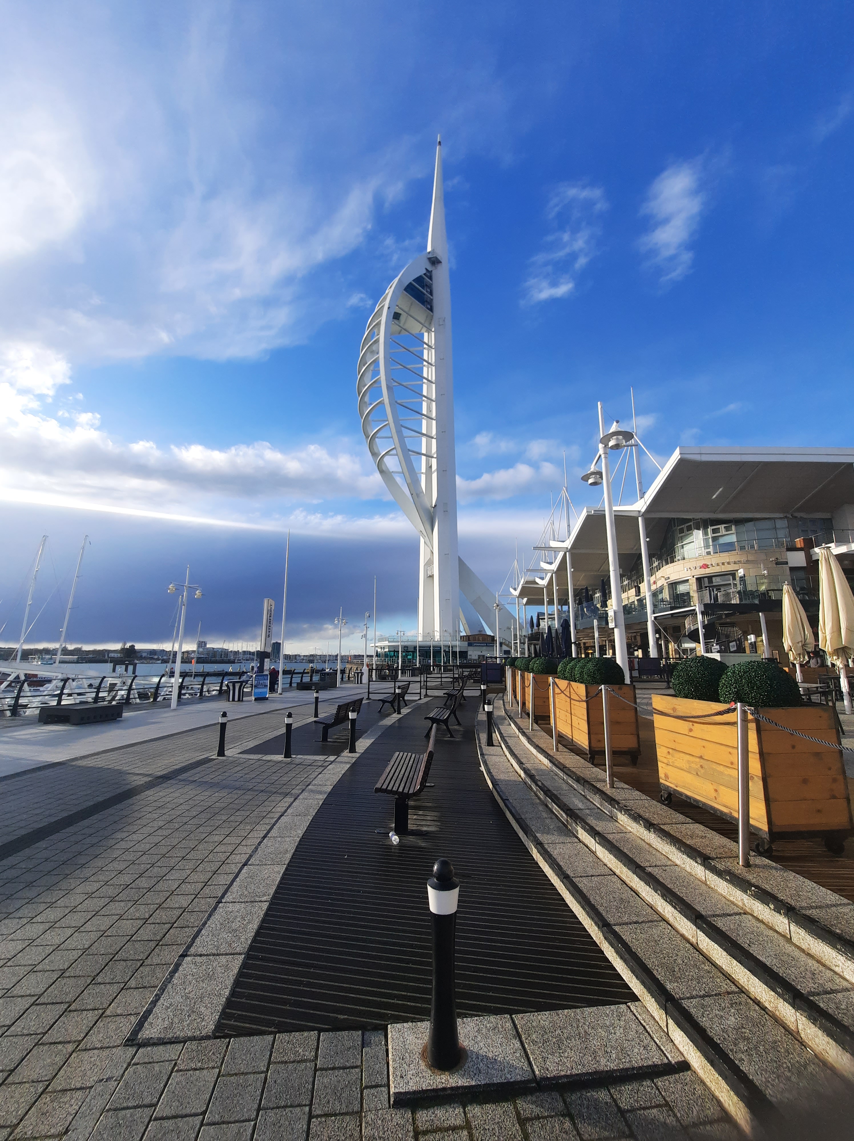
The final section just skirted around the harbour, with some fishing boats, the IOW ferry and then through Gun Wharf Quay. This is a huge shopping center built right on the old quays, in the shadow of the Spinnaker Tower. I first saw the tower from Selsey, four days and nearly 100km of walking ago. Portsmouth Harbour station is right on the coast, so it was nice not to have to make any diversion to catch the train home. My train was waiting for me, as well as a train to Cardiff. I didn’t know that route existed and might be some useful future information!

I’m surprised that after writing this up, there was much more going on than I would have thought when I started writing – I guess that the value of blogging about these journeys. It has also just occurred to me that I haven’t shown the elevation profiles for any recent walks. That is probably because I have seen a single hill of any description since Brighton!

