I was hoping to finish the Dorset Coast Path by the end of 2025, but due to circumstances outside my control I had to cancel walking before Christmas. So I need a big push to get to Devon in January so I can count it as being walked in 2025. I’ll just ignore I started walking in Rye at the end of 2024, and claim I’ve walked the coast path of four counties in 2025 (East Sussex, West Sussex, Hampshire and Dorset). Hopefully, I can make it to the Devon border, but the weather forecast isn’t too promising.
I’m getting so far from home, so even though I only have about 30 km to walk, I’ll need two days. Even with two days, I need a ridiculously early start, being at Burgess Hill station before 6am. The train journeys aren’t too bad, but it seems I have a 30-minute wait at each change of train, which adds an hour. That said, it was nice sitting in Brighton Station at 6:15 (with a Pret coffee and sandwich), seeing the gradual build-up of commuters.

It was raining for the whole journey, particularly at Southampton Station, where the sound of the rain drowned out all railway noise – including a freight train with at least 40 containers on board. That’s a lot of lorries that don’t need to be on the road.


Staying on the railway theme, this would be the last time I needed to come to Weymouth (I’m getting into the West Country train routes after this). Each time I have come into Weymouth, I have a vague recollection of being on a train that drove through the streets. I think it was on the way to a scout camp on Guernsey back in the 1970s, so presumably, we were going to catch a ferry. I had looked for evidence on previous visits, but the railway line finishes at the station, with nothing to suggest it carried on. This time, I decided to Google it, and sure enough, the train went straight through town. The photos suggest that marshals walked in front of it. I’m glad my memory isn’t failing! There are some great pictures of the trains towards the bottom of this site. https://www.cornwallrailwaysociety.org.uk/weymouth-street-tramway.html
At Weymouth, I had another 30 minute wait for the X53 bus to Abbotsbury, which turned up bang on time. I got to the start at about 11:30, and decided to stop for a coffee straight away. I went into this gloriously old fashioned tea rooms, with a tie wearing patron. It was busy with a good number of locals, seeing as it only had five big tables. I selected a sausage roll and a coffee before heading out onto the coast path.

As soon as I left the cafe, I walked in the wrong direction, then took refuge under a pub porch to put my waterproof trousers on and sort out my woolly hat and gloves. It’s the first time I’ve worn the trousers and I had to remove the labels! I then continued walking in the wrong direction. I think I was just keen to walk through the churchyard and flower meadow I’d seen on the last leg. Anyway, I realised my mistake and had to walk right back past the cafe, I could imagine all the locals rolling their eyes.

I took a side street out of Abbotsbury and was straightaway plunged into lovely little lanes. It wasn’t raining, but I appreciated the warmth of the overtrousers, and especially the hat. It was a series of slippery flooded lanes down to Chesil Beach, or where the beach rejoined the land – it stretches nearly 30km from Portland. The paths were really tricky, jumping from side to side and trying to avoid submerging a boot, or worse, slipping over.


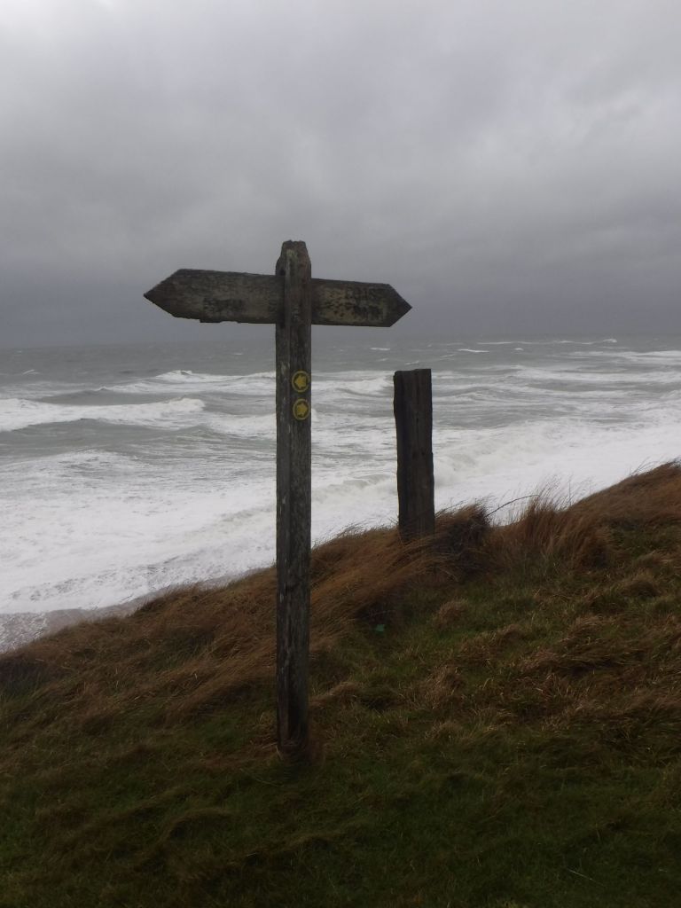
The shingle bank of Chrsil Beach came into view and provided some shelter from the wind. It was still really high, and it took a long distance for the coast path to climb to the top level, so I could get a view of the crashing waves. I don’t think I’ve mentioned it, but it was really windy.

The path ended up on the beach, and the soft tiny pebbles left me wanting the muddy puddles. Shingle is energy sapping. I reached a carpark and remote cafe that I had marked on my map, rather obviously it was closed. I think it would go out of business really quickly if it was waiting for me to turn up as I had seen nobody else since leaving Abbotsbury.

I was relieved when the path followed the coast road, although the term “coast road” makes it sound rather more substantial thant it is. There were still plenty of full width puddles to be negotiated, often requiring clambering up the embankment, and then often leading to a boggy quagmire. Despite this, it was better than shingle.

The road petered out, and lead down onto the beach, and the dreaded shingle. There was nothing for it but to just start plodding. One technique I developed, was looking ahead to see if there were any subtle contours that could be traversed. Otherwise it was a bit head down and finding yourself with a steeper bit, which was much harder.

After a few kilometres (on the shingle I was averaging only about 3 kilometres per hour – really hard slog). I was hopeful that the path turned inland a bit. On the map it went behind a few lagoons, but when I got to the turn-off, the signage suggested the winter route was along the beach. I think this is because the lagoon water levels must block the path.

So it was back plodding on the shingle. I did spot a couple of walkers on the otherside of the lagoon. They stood looking at me on the lovely shingle and appeared to be regretting their decision to take the “summer path.” Well, that’s how it played out in my head, and help me considerably with the trudging. Eventually (whenever I type eventually, I pronounce it in my head like Manual in Fawlty Towers, something about forgetting that Basil had won on the horses), I hit the first cliff section and was able to get off the beach, and climb some muddy slopes. After skirting a caravan park, I found the first bench of the walk and stopped for a wind blown sandwich.

After my really needed sandwich and a drink, I dropped down into Burton Bradstock and stopped for a coffee in a cafe. I was much more tired than I should have been, I think it was something to do with the wind and the endless shingle. That said, it was a nice type of tired! From the cafe, I followed the obvious path for about 100 metres, but it just disappeared at a cliff edge/fall. A quick look at the map, and I retraced my steps and headed inland. I think cliff falls are a regular thing on this section of coast. In fact there was a cliff fall on the local news a couple of weeks ago, and caught on film. When I got to the high path, the wind really picked up, and I found myself keeping near the fences, for protection and potentially something to grab if there was a big gust.
The path dropped steeply down to a caravan site and small river. The path was treacherous and was the site of my first slip and landing on my bum. I could see it happening, but with only one walking pole, there was nothing I could do to save myself. The path headed inland along a small stream and over a bridge into a caravan site. I was entering “Broadchurch” territory. We binged watched Season 1 of the detective drama over Christmas, and one of the suspects lived on this caravan site.


As I crossed the site, I noticed a “Coast Path Diversion” sign, and given the recent falls (both the cliffs, and myself) I decided to take the safer route. It headed out of the caravan site and up onto a golf course on the cliff top. I’m sure this was an easier route, but given the wind, the time of day and how tired I was, it was the right choice.

The path dropped down into West Bay, which is the main setting for Broadchurch, and is really Bridport Harbour with Bridport town a mile or so inland. West Bay was the biggest town I’d seen today, and when planning the walk, I had thought I would stop here. However, it was getting late, and I had a few miles still to go, so I limited myself to walking up to the beach for a view of the cliffs and a stroll around the harbour.


I headed out of town on the Esplanade but soon had to head up onto the cliffs as the Esplanade was a dead end. I knew this was the final hill as I was going to Eype in the next valley. I slipped over on the next descent, which was a more comic occasion than the first time as it happened in slow motion. While sitting on the ground, I looked to my right and saw some steps down, which would have saved me getting muddy again. Crossing a final stream (which on the map is grandly called Eype Marina, and is actually a few canoes and dinghies dumped in the stream).


It was a longer walk (plod) up the road to my hotel for the night. It was a relatively fancy hotel, but I had a plan given the state of my muddy boots (and clothes). I’d packed a big bag to put my boots in, and with my waterproof trousers removed and a pair of sliders, I looked reasonably respectable. I’d been upgraded from my single room, and complementary cakes were provided. Nice.

The evening was polished off with a couple of beers, a sirloin steak and Traitors – perfect. I’m not sure what the weather may bring tomorrow, but I have about the same distance, but with three times the amount of climbing (and more worrying for me – descending) so I’m hoping its not too wet and windy.


