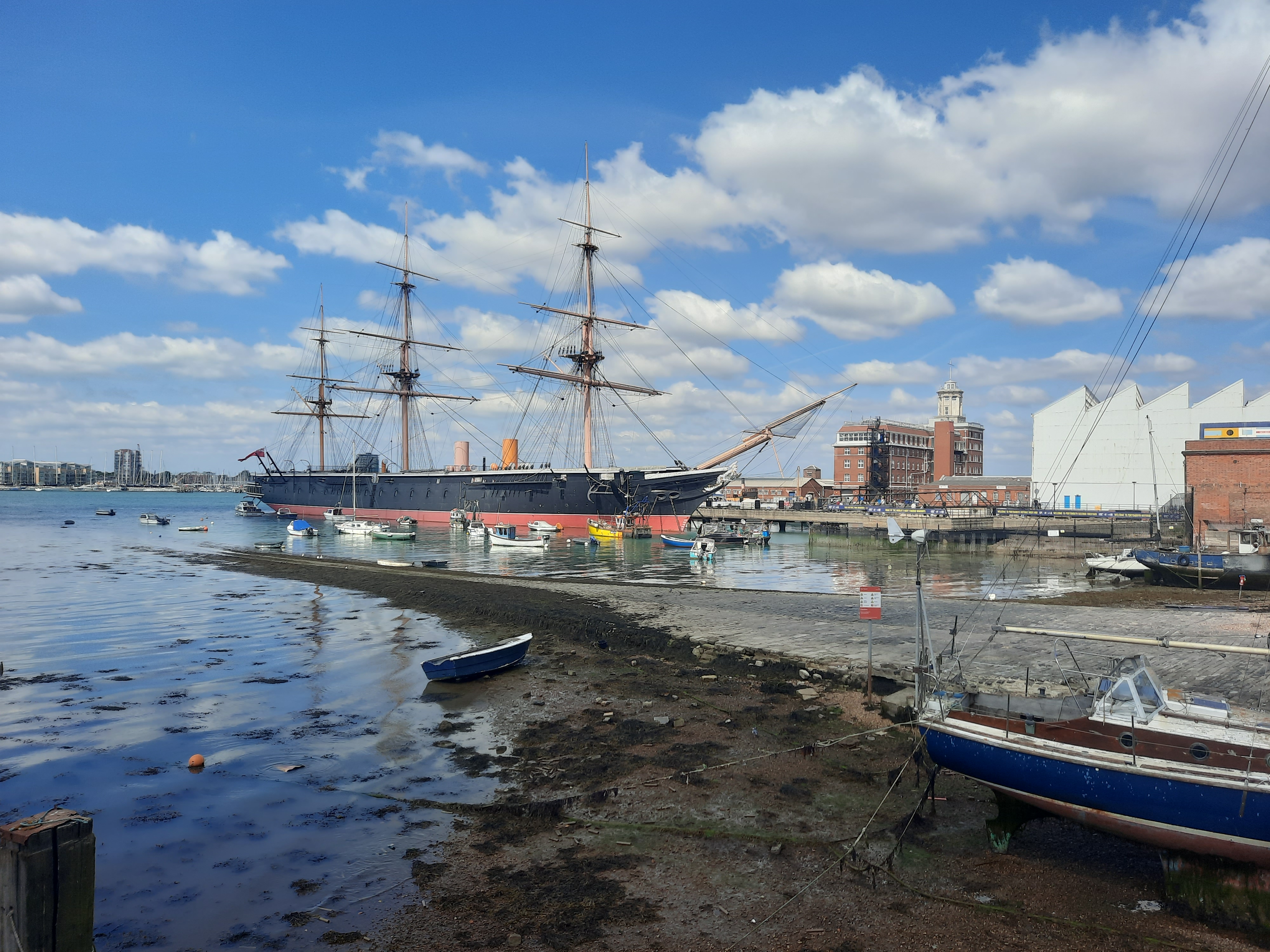
I’m getting used to catching the train to Portsmouth, its a bit like a commute. Although today would be my last trip into the city. Todays walk would start with the Gosport Ferry, which is right next to Portsmouth Harbour station, but remembering I’d missed bit of the coast path I got off at Portsmouth & Southsea and walked. The bit through the park was nice, and after googling all the naval monuments for last weeks walk, they seemed more impressive, just knowing some of the back story. It was then onto the main road towards the harbour, past a few impressive naval buildings and then just the high brick walls guarding the historic shipyard. One point of interest was passing the Ship and Compass pub, which only last night had been on TV. It featured on Ross Kemp’s (Eastenders Grant Mitchell) “Who Do You Think You Are” where his great-great (or something) grandfather was born and brought up. Its a big pub, but they made it look small and humble for the TV.

It was a very short stroll to the Gosport Ferry for the five minute crossing. I didn’t have long to wait and I managed to find the small ticket from last week that gave me a return trip. It seems you can’t buy single tickets, but I guess who would want one (given that the shortest way around – on the coast path – was over 30km) except a hard-core coastal path walker who never retraces their steps (unlike me!). It was another fine day so I enjoyed the sun on the deck with fine views of Portsmouth and the Spinnaker Tower.
The Coast Path was well signposted in Gosport and I headed off on a well used promenade. The path soon got sent inland due to more naval establishments and shipyards, although I did get a glimpse of a submarine and I really must visit the Submarine Museum, hopefully you can go inside a sub (a thought that both intrigues and panics me at the same time!).

On the TV front, I passed the Royal Haslar Hospital, which had appeared on TV last week with “Interior Design Masters” where contestants “decorated” (I am be doing them down haha) show flats during its conversion from former naval hospital to retirement village. It is certainly a fancy looking building, and Wikipedia says it was the largest hospital when it was built in 1740 and its the largest brick building in Europe – an impressive pedigree and really good to see it being reused after 250 years as a military hospital.

The coastal path then headed back towards the coast, with a loop around a prison. I had to take a short cut as this section looked a bit exposed (and had CCTV) as I was bursting for a wee with no trees in sight. The straight line route rejoined the path with a suitable array of trees and bushes. Shortly after this section I should have been able to get down on the coast and escape the urban/suburban areas, but unfortunately some sort of works blocked the path across a golf course.

The only alternative was along a very narrow lane, which initally had a rough verge to walk along but ended in a busy, wiggly, small lane with impenetrable bushes on either side. This was probably the most risky part of the whole coastal path that I’d walked so far. I had to keep switching sides to stay in the drivers sight-lines, and when two vehicles came at once I couldn’t get out of the road and traffic stopped completely. For one lorry, he waited while I passed on the otherside. It was a disaster and I felt like having a sign saying it wasn’t my fault, and blaming it on the golf club (which incidentally the works hadn’t stopped the golfers). It was all pretty dodgy and I’m sure there would have been room for a temporary path across the course, but it needs someone to consider the needs of walkers. If the person who had signed off the closure had walked the alternative route I’m sure there would have been a different outcome.

Anyway, I soon got back to the coast, although in some ways it seemed more like a river as the Isle of Wight seems incredibly close! I’ve subsequently measured it on the map and it’s at least 5km, but seems so much closer.

A good length of promenade brought me to Browndown Beach, where I could see some strange looking tanks. It turns out it is the Diving Museum. There are so many museums in this area! The coast path headed inland along a lot of busy roads and cycleways. When I got to the far end it seems this was unnecessary as there is a Permissive Path across the Military ranges (when they are not using it!). It is signposted and marked much better at the western end, and hopefully this information might help those following from the east – it will certainly be nicer than the roads.


From here it’s a really nice promenade all the way to Leigh-on-Sea. There are plenty of plaques and monuments remembering the planning and the troops embarking on the D-Day landings, which is nice to see.


I’d identified Leigh-on-Sea as a good spot for lunch and I wasn’t disappointed. It’s a tiny bustling little place with plenty of cafes, and most importantly a Co-op. I bought some supplies and headed off with a plan to find a nice bench later. Before leaving I wanted to find the Hovercraft Museum, as my walk past the Southsea Hoverport had brought back memories of the huge Cross Channel Hovercraft. It was shut, but I did get a glimpse of the “Princess Anne” Hovercraft parked outside. I can remember crossing the channel on hovercrafts like this (maybe even this one). It could carry 250 passengers and 30 cars. Its amazing that the Isle of Wight hovercraft is the only regular ferry service left in the world.

It was fairly typical holiday area coastal path from here, with promenades and beach huts. On one section the route headed around a private estate, but the tide looked low enough to cross the beach. It was fine although I was glad to have warn my boots as I would have got wet feet just wearing shoes.

The very pleasant path continued either on a promenade or on country paths. At one point I got to another inland diversion around a caravan park. Looking at the map it was possible there may be a stream flowing out across the beach. At the diversion point I would have had to walk down to the beach through some woodland to scope out whether it was passable. I was tired and couldn’t be bothered so took quite a long diversion on good paths. I think the time spent here will come back and haunt me later. The biggest treat I had on the walk, was just after seeing the yacht with the best name ever “Jam First”, when I was treated to an excellent sand rat show! There were lots of rats on the beach fighting it out wih seagulls for the best treats! They were oblivious to me on the (safety of) sea wall.

My intention today had been to walk to Woolston, which involves catching the Hamble Ferry. I had looked up the details in my planning and had even put the ferry phone number in my phone, as it works an on demand system. The one thing I hadn’t kept at the front of my mind was it’s hours of operation. I think I had 5pm in mind. However, as I was getting closer to it, I decided to check and found it was 4pm. Google maps said I wouldn’t get there until 4:20 – damn! I still had over an hour to walk, so felt I could outperform google maps so headed off at top speed. Unfortunately the route turned to my favourite, shingle! I was walking as fast as I could, which surprised me as a few minutes before I was too tired to look and see if there was a shortcut across the beach.


Warsash came into view and I got to the ferry shelter at 4:05 but unfortunately it wasn’t there, it was visible on the Hamble side. I had rung just before 4:00, when I knew I was only going to miss it, but I think they must turn their phone off fairly promptly.

Anyway, things like this give me the oppertunity to do my favourite past time of ad-hoc re-planning. Looking at the map Bursledon station was the closest, just over an hour away, but only had hourly trains and I would miss one by 10 mins. It looked the best option but then Google Maps came up with a bus option to Woolston. On paper it just made the train I needed to catch, but in practice it was the second form of transport I missed by five minutes this afternoon. It was a really nice walk up the Hamble esturary so missing the ferry hadn’t been all bad. I think it adds about an hour each way to the coastal path, and on the positive I saved myself the £2.50 ferry fare (which I had to spend on the bus!).

Looking back, the main thing I have forgotten to mention, is that most of this walk has been done with the chimneys of Fawley Oil Refinery in the distance. Even when walking through the countryside was nice, the chimneys were always there! I guess I’ll have to walk right past them at some point in the future.


