I had been getting out to walk on a Wednesday, which is one of the joys of being (semi) retired. However, this week, the UK had been battered by storm Bert, which had rather put a dampener on the weekend, and a new storm was forecast for later in the week. As such, I put my trust in the Weather Apps and decided to walk on Tuesday. It would prove to be an excellent decision, as the next storm arrived as promised. It was named Storm Connall by the Dutch weather forcasters, apparently, as it was going to affect them the most. This seemed a strange name to choose, why not Noah (the most popular boys name in Holland). Once again, Google is my friend, and all storms that are likely to affect either Britiain, Ireland or the Netherlands are given names. The list of names are predetermined, in alphabetical order, each September and the any of the three countries can declare a storm they think will affect them. The next storm will be Darragh, which is presumably the Irish influence on the names. You can put forward name suggestions for next year, and I’m quite looking forward to when Storm Mavis hits us.
Anyway, I headed off to Wivelsfield Station on a slightly damp morning, although it was a good bit warmer than than last week, with no frost. I allowed time to buy a bacon roll and a coffee at the sandwich bar next to the station and ate it while waiting for my 15-minute late train. I’m trying to travel off-peak when I can, but these delays are eating into the available daylight at the end of the day. It was a nice trip to Eastbourne and the last time I would visit on these journeys (unless/until I tackle the south coast of Kent). For a change, I sat on the opposite side of the train. I was treated to a good view of “The Long Man of Wilmington” but I don’t think my picture does it justice as I decided way too late to find my camera for a picture from the moving train.

I arrived into Eastbourne, fashionably late, to a nasty drizzle. I tried to ignore it, but by the time I’d reached the Pier, my down jacket was getting a bit damp, so I had to switch to a full raincoat. It was a bit disappointing but was by no means bad weather. At this point, I want to include an interesting thing that I missed off last weeks’ blog. On Eastbourne Seafront is a big piece of modern art, which, upon closer reading of the plaque, is a hugh white tooth. This was to celebrate finding the remains of “Beachy Head Woman,” which was dated to around 125 to 245 AD (or CE). She was thought to have originated from Sub-Saharan Africa and had been named as the “first black Briton”. However, Google shows that further analysis suggests she may have originated from Cyprus, but none the less shows the extent that people travelled nearly two centuries ago. I must admit that Cyprus seemed quite appealing while walking in the drizzle.


I started walking along the seafront with Beachy Head looming ahead. I knew it would be quite a climb as I’ve walked or cycled up there a few times on the South Downs Way, although on the map, the Coast Path takes a slight more indirect route. Leaving the Seafront meant a steep climb up to the road. I have done this climb a few times, most notably during the Eastborne Duathalon, during lockdown, where the run finished up this hill, twice! Once on a 5km run before the bike ride, and after a 2.5km run ,”sprint” to the finish after a 20km bike ride on the roads over Beach Head. Killer! All of this had warmed me up enough, and the weather was brightening, so I could discard my coat and just get hiking in my lightweight fleece top. Pretty good for late November!


Once onto the road, it is a short walk to the “trailhead”, well the start (or finish) of the South Downs Way. I was a bit surprised to see that the cafe was shut as I would have had a coffee. I headed up a steep muddy path, pausing briefly to get my poles out before I slipped over and become a complete muddy mess. I’d brought both poles out with me today, expecting some steep climbs, but they proved most useful in the mud. Soon I got out onto the cliff top with an excellent view back over Eastbourne, and back all the way to the Fairlight cliffs which was the last climb I had, at the end of my first day.

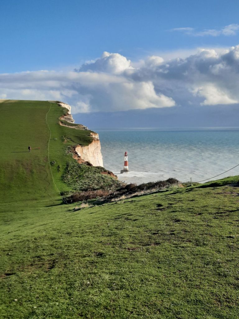
The path skirted some, strangely located, football pitches, and then climbed up to a viewpoint. I think this was Beachy Head, although as the path was remote from the road, I hadn’t realised that I was near the Pub and Golf Club that I’d always associated with Beachy Head. Beachy Head is the highest (chalk) cliff in the UK at 162 metres high (the highest cliffs on mainland UK are 250m in North Devon), and there is a spectacular view. There is also a very poignant memorial to the World War 2 Bomber Crews, for many of the 55,000 who lost their lives, Beachy Head would have been their last sight of Britian.


This was my first sight of Beachy Head lighthouse. I’m sure I’ve seen it on many occasions but I must admit to forgetting what an impressive sight it is, located at the bottom of the cliffs. It was built to replace the Belle Tout Lighthouse located on the cliff top. This is because Belle Tout was often shrouded in mist and fog being so high up. There was no mist today, and it was turning into a fine sunny(ish) day.

Belle Tout Lighthouse is quite a landmark, and by the looks of it, a fancy B&B (pricey, but the Lantern Room looks fabulous – but it is not a bedroom). Its appeared on TV a few times, I can remember “The Life and Loves of a She-Devil” in the 1980s, and also a programme about how the moved the whole lighthouse away from the edge of the cliff. In 1999, the whole 850 tonne lighthouse was moved enmasse 17 metres to relative safety. Looking at the cliff and a few large splits, I wonder whether it needs to be repeated.

From here, it was glorious, up and down, walking until I reached Birling Gap. Here, there is a row of cottages, of which the last few have disappeared over the edge! I treated myself to a nice National Trust lunch while looking out the window at numerous Japanese tourists. I don’t know why they are attracted here?


From Birling Gap I headed over the Seven Sisters, these are the names for seven peaks (and corresponding troughs) of the beautiful white ciffs. They are named Went Hill Brow, Bailey’s Hill, Flat Hill, Flagstaff Point, Brass Point, Rough Brow, and Short Brow. They all look the same, with nothing to differentiate any of them. I was rather hoping for a Flagstaff on Flagstaff Point so I could orient myself. I expect these paths are very busy at weekends and in the summer, but it was glorious having them pretty much to myself in the sunshine today. There were a few people out, including a flim crew, but it was so quiet.


Soon Cuckmere Haven (and the Cuckmere River) came into view. This is the biggest diversion I have made so far on the Coast Path, where I need to head inland to a bridge, purely to end up a few hundred metres away across an esturary. I eyed up the river flowing across the beach and thought it looked passable. But would it be cheating? I wasn’t sure, but I was pretty sure it was bound to be deeper and more epic that it looked. So I took the long path to Exceat Bridge and headed back up the other side of the estuary. I went down to the beach on the other side to hopefully see how deep the water was. I’m not sure if the river was crossable, but I had this nagging feeling that an hour had been lost. This sort of diversion is going to become more common as the coast path becomes more wiggly, so I’ll have to improve my attitude! I’ve since read a few reports that you can cross at low tide, but the water is fast, and you will get wet feet, so I probably made the right decision. It wasn’t all bad as there was plenty of bird life in Cuckmere Haven, and it was a nice walk, except for the muddy puddles!


The route passes the Coastguard Cottages. This is an iconic row of cottages that are often photographed in the foreground to the Seven Sisters (and appearing in numerous films). I tried for the iconic shot but couldn’t really see how to get it without deviating a long way from the path. Anyway, there was a nice bench, with a cracking view and a chance to sample coffee out of my new flask (an essential for winter walking!).

It was just now another climb up the last hill/cliff of the day to Seaford Head. There was a golf course at the top and a great view of Seaford in the quickly arriving dusk. Seaford looked far bigger than I’d imagined. From this viewpoint I could see Brighton in the distance, which woud be the last leg of East Sussex, and in the far distance I thought I could see Selsey Bill which would be a few days walk away in West Sussex. The hill down was trechorous with very slippery mud, which had incredible “clumping” charachristics, and made my boots weigh about twice as much. Just what you need at the end of a long walk.

Seaford has a very long seafront walking path and there were quite a lot of people out taking the evening air, which was nice after such a quiet day. The seafront is not at all developed, with a few tea/coffee kiosks and not much else. I could see the telltale yellow flashing lights of beach works ahead. The whole beach doesn’t have any groynes or breakwaters, which is really unusual compared to all the other beaches I’d passed. The shingle was being excavated at the western end of the beach and being brought to the east with a long convoy of huge trucks.

It was really beginning to get dark as I got to a headland at Newhaven Harbour. There looks to be a lot of history here, with some old Tide Mills and the remains of a hospital (Chailey Heritage Marine Hospital, Chailey is about 15 miles inland which is confusing!). The path got very stoney following old railway lines, before diverting inland along a very narrow muddy path following the river, which was (not) a really easy walk in the dark!


I haven’t mentioned sewers or sewage works today! So to remedy that, I passed the Newhaven works and initially was really impressed as there was no smell. However, a footbridge crossed the railway nearby, and at the top of the bridge, the onshore breeze blew the full effect straight into my face. The smell carried with me all the way to the railway station! The coast path passes right in front of the station, which makes navigating to the next starting point really easy.


I think this leg is definitely the jewel of the East Sussex Coast. The next (and final) section is a bit of cliff walking before hitting the streets of Brighton. I’m thinking I may incorporate my Christmas shopping!
