Before I start, I’m not expecting this leg to be very interesting! It is an almost completely flat section, initially through the coast suburbs of Hastings and Bexhill, then a long stretch across the Pevensey Levels before getting to Eastborne, which is a fairly sprawled out town…. But don’t worry it was pretty good!
I headed off to the train, allowing a little more time than last week, and got to Wivelsfield Station with a couple of minutes to spare. Luckily, the train had a 10 minute delay, which meant I could get a coffee and a nice bacon baguette from the sandwich shop next to the station. This was most welcome, as I’d only managed to leave on time by missing breakfast at home! I think this could become a thing for the next few of the eastern legs (Wivelsfield Station is great for trains to the east, while Burgess Hill Station for trains down to the coast and westwards, which is well supported with a Greggs on the way to the station). There has been a big change in the weather with the temperatures dropping to O°, and a lovely frost. Although, I nearly slipped over on the path to the station, which could have been a disaster!

The delayed train meant a wait to change trains at Hampden Park (Sussex). The brackets have been added to the train app, as I think you would be disappointed if you turned up expecting to see Scotland play football. Anyway I got to Hastings by about 10:30, a slightly earlier start than last week, but the evenings are still getting shorter (the charts say 8 minutes lost from last week, although I gain an additional 1 minute by walking west). It was interesting walking from Hastings Station to the Pier, a real comparison from last week, tired in the dark, to this week, fresh and daylight. A real contrast and very different feelings. On the way to the pier, I went under an underpass to cross the road, and had an urge to turn into an underground carpark. I was treated to the amazing sight of a large sewage pipe. To be fair I did know it was there (or rather somewhere), as back in the 1980s, we found it during surveys for the Hastings Hydraulic sewer model, and it let us measure it accurately. Pipes are normally buried and hard to know the exact size, but someone had the great idea to lay this one in the underground carpark to save excavation cost/disruption. (For the technically minded, this is a rising main).

When I got to the pier, even though it was still chilly, and the sea breeze didn’t help, I decided to take off my down jacket to encourage some brisk hiking. It was bright weather and quite nice out of the wind. I say one person sunbathing, it certainly wasn’t that warm, and they were clearly a nutter. One thing I hadn’t known about the Hastings sea front, was the double layered promenade walk. It is quite different to other seaside resorts. Its called “bottle alley” and I think the columns are painted a slightly different shade, which was lost on my mild colour-blindness. There is a plaque to the Water Engineer (?) who proposed it and was known as “The Concrete King”. Its quite a cool structure, but it has a slightly menancing, and remote feel, even during mid-morning!


I could see Beachy Head in the distance, with Eastbourne sitting just below it. It doesn’t look very far, but I knew it would take all day. I’m beginning to calibrate my horizon/distance mental calculator. On the subject of distance, I didn’t need to use my map all day and the signposts were largely redundant as the way is clear, and as such avoided any miles/kilometre calculations. I just walked. The railway line follows the coast, and I was walking on a narrow piece of land as Hastings gradually petered out squeezed by the railway. There is a very large rail depot right on the sea front, this would be prime real estate in many places. This bit of the coast is real beach hut territory. Dozens of beach huts, all quiet on a cold winter wednesday morning, but I can imagine what they are like in the summer. The coastal path follows a National Cycle Network route, and was a good surface. Even the shingle paths were compacted for bicycles, it was easy walking. Ahead was the only slight hill of the day with the cycle path snaking up it. It was Galley Hill, with a coastguard station and good views of the Channel. The greenery of the hill splits up the urban areas of Hastings from Bexhill-on-Sea.

Last week, when I started the Coast Path, I had a nagging feeling that I should have a dip in the sea on each leg. I may have been tempted if the path down into Fairlight Bay had been open, but it was closed due to cliff fall. Today, it hadn’t even crossed my mind as it was so cold, until I passed a load of ladies taking a dip. All their shreeking and complaining made me pretty sure that I’d made the right decision.

Bexhill has a completely different feel to Hastings. Beautifully manicured lawns surrounding modern (well 1970s) apartments (it seems rude to call them flats) and grand victorian buildings, most seem to be named after Caribbean islands. Towards the centre, the seafront is dominated by the magnificent art deco De La Warr Pavilion.

From here it is was a long way along the sea front, with the path occasionally diverting into streets behind the coast. This occurred more often as it became more suburban, and the beach front houses protect their privacy. After Cooden Beach, the houses petered out and it was long lengths of walking on loose shingle. It was exhausting. I became expert at identifying the shingle size and estimating the most compacted walking line across the beach.

There were some brief but very welcome sections in roads, through tiny little enclaves of Normans’ Bay, Pevensey Bay, and Beachlands. They are outposts of beach front properties and small estates, which I suspect have grown from caravan parks or summer cottages. Some of the beach front houses are really grand and nestled next to very modest seaside shacks. Its pretty clear that their days are numbered with climate change and sea level rise. There are works to increase the height of the shingle beach all along this coast. There are maps showing how the coast was centuries ago and where it may return to in 100 years. Global warming has a lot to answer for, as the coast path here will be much, much longer in the future!


The main feature along this length of the coast are the Martello Towers, fortifications built to defend against an anticipated Napoloeonic invasion. They were never required, but many are converted, into what must be, very strange houses.

The remote coast path slowly transitioned into the highly intensive new development at Sovereign Harbour. I’ve not been here before and was very surprised by the scale of the development right by the coast. Once again, Google tells me it is (Northern) Europe’s largest Marina Development, and was made possible after the Minisrty of Defence made lots of land (previously no mans land) available. I guess it could be a pretty nice place to live, but on the face of it, it seems a bit out of place.

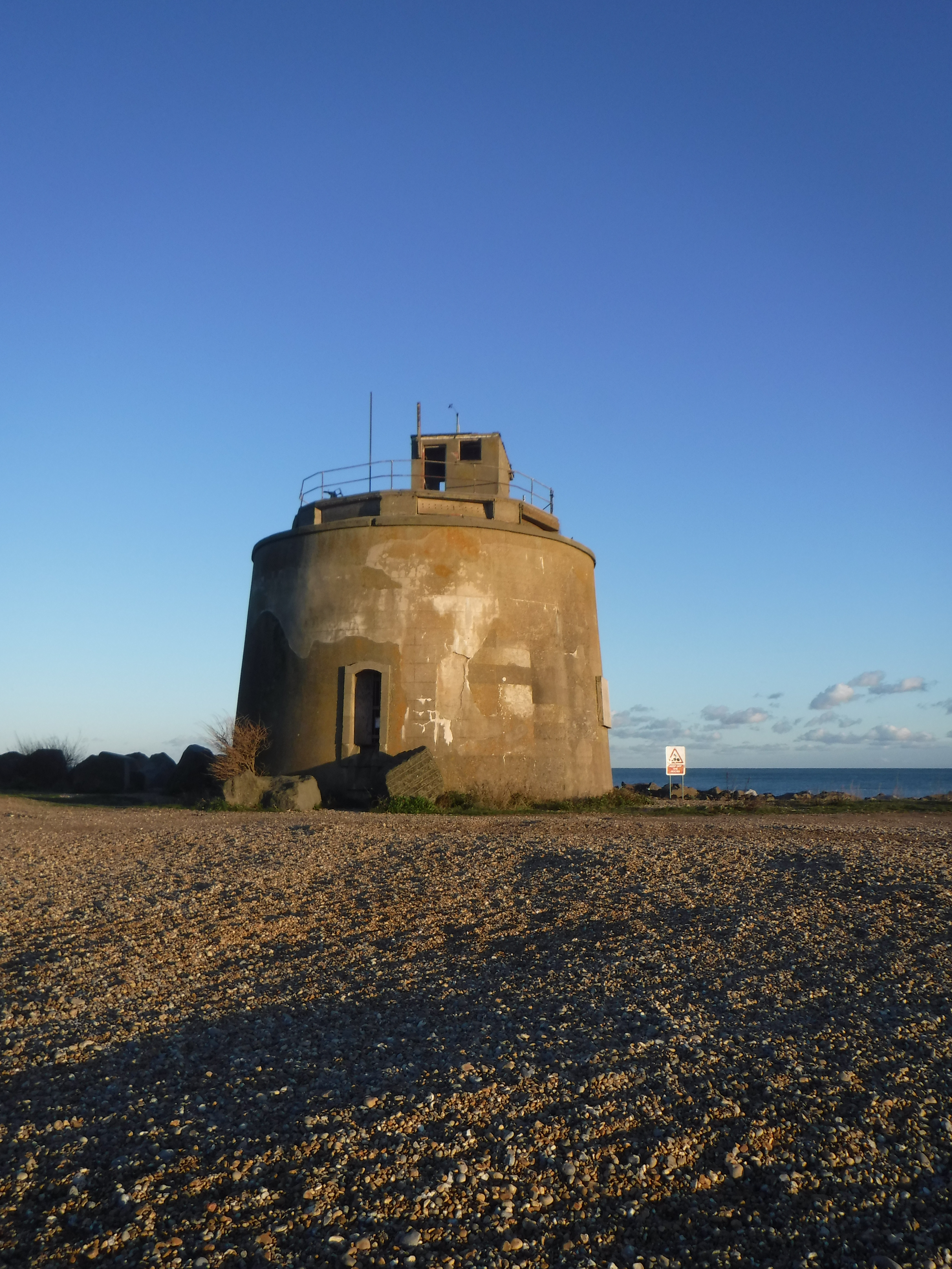
After a walk through the new development, narrowly avoiding getting delayed by the locks to the inner harbour opening for a fishing boat, I made it to Langley Point. Langley Point has a rather magnificent Martello Tower, and a rather cool Sewage Treatment Work that looks like a castle (with some very informative posters on how sewer networks are designed to perform in rain – I wonder if anyone has read them!) .


It seemed like a very long walk along the Seafront to Eastbourne Pier. It wasn’t getting as dark as last week, but with Beachy Head and the South Downs looming behind the town, the sun was disappearing earlier. Despite the coast path being almost completely flat, the road walking, and especially the shingle, had completely exhausted me. It was a long, slow amble from the Pier to the Railway Station, and it was nice to sit down on the train. It wasn’t so nice trying to stand up again to get off the train! I’m expecting the next section to be harder, I hope I’m ready!


