It was rather nice packing up my rusac to head out for the first leg of the coast path. It was a nice flashback to the Camino, heading off each morning into the unknown. Although walking in Sussex is significantly less unknown and I have a pretty good idea of what is ahead. I think the East Sussex coast should take about four days, split between two pretty flat days, and two with a bit of climbing. The first day is a climbing day, but that said, the first half is completely flat before heading up over the cliffs into Hastings. It should be a good taster, as I’ve always enjoyed walking over the cliffs and woods at Fairlight.
I left the house too late! I was heading for the 8:08 train at Wivelsfield, which would have needed one change to get me to Rye to start walking by 10:00. However, I missed the train by two minutes! I could have run, but I thought was was further behind schedule than I was, and I’d never of have enough time to buy a ticket. So a 30 minute wait at Wivelsfield, followed by a 30 minute wait at Ore got me to Rye for a 11:00 start. Not ideal on a winters day when the light starts to go around 16:00. Anyway, the wait at Ore did get me thinking about the shortest railway station names! My journey between Ore and Rye must be two of the shortest names. The others I could think of, were a Scottish city on the west coast, south of Glasgow, and a cathedral city (?) in the Norfolk broads. I wasn’t sure whether both these had railway stations. A google afterwards shows that they do, and in total there are 10 ,three lettered stations in the UK. Including one called IBM that I’m a bit suspicious of!

Rye is a nice little town with lots of local shops, and plenty of mentions of the Cinque Ports (which again I have had to google as I can’t properly recall my schoolboy history, but was completely different to what I thought) of which Rye is one of the five major ports on the south coast in the 14th century, or something. I didn’t spend too long in the town, but it has a nice feel, looks to have some nice pubs and I didn’t see Paul McCartney. It was a bit “roady” to get out to the coast (but the coast path passes right through the town), but once I crossed a sluice gate on the River Tillington, which is the first crossing point from the sea, it seemed I was heading in the right direction. The road was alongside the river / estuary and there was lots of industrial units. This included a mini oil refinery (?) with solvent recycling and, by the look of it, cheap diesel being sold out the back ;)

Before too long I made it to Rye Harbour, and my first views of The English Channel. It had turned into a lovely sunny day. I was heading to the west, with the higher land and cliffs, I would need to go over later just visible in the distance. To the east, much flatter land with Dungeness Nuclear Power Station dominating the horizon, on a very flat looking spur of land.

Close to the entrance to the harbour were two ruins to remind me of the history and importance of this length of coast and how near we are to France. Firstly, a concrete World War Two pill box on the foreshore looking exactly like all those I saw facing us in France earlier this year. A little further back from the shore, a Martello Tower, built in the early 1800’s as a defence against Napoleon. I expect I’ll see plenty more of these as I walk along the south coast.


It was nice easy walking along the raised berm between the sea and the salt marshes behind. There is not much protecting the low-lying land. Although it looked like some works were taking place to reinforce the gravel berm, presumably before winter storms. I’ve seen more Environment Agency trucks and other vehicles today than I have for years. As well as the bulldozer on the berm, I’d seen teams working on lock gates and a sluice valve. Clearly, there is lots of work being carried out in these areas of higher risk areas of coastal flooding and, presumably, having to reinforce due to climate change.

There wasn’t too much to see, apart from the occasional derelict building or abandoned Lifeboat Station. That’s a bit unfair, but it was nice ambling along with a steady stream of walkers, just wondering whose dog was whose, or catching snippets of interesting conversations. It took over two hours to reach the cliffs. I have commented before how the horizons in the UK are much further than other countries. In Spain, when I was confronted with a hill on the horizon, it seemed after 30 minutes I was over it and onto the next. This is not true here – its a really long walk to the horizon. When I looked back Rye town seemed really close yet it was over 10km away, the coast path signs said 5 miles to Rye, which was confusing. At this point, I must say I am slightly conflicted to my unwritten rule about sticking to kilometres. It makes real sense when cycling, but when walking, and all the footpath signs are in miles – it makes it more difficult. Not that have much concept of what a mile is, or what it looks like on the ground. Its more confused as our maps are metric with kilometre grid squares. If asked, I could estimate 1000 metres ahead on a walk, but trying to envision a mile seems more meaningless. I sometimes thing it would have been a really good idea if all new road signs, after we went metric in the 1970’s, had of included both miles and kms (in brackets maybe). It would make a transition so much easier. So I may mix and match my units. All the Coast Path signposts are in miles, giving me some mental arithmetic, which is really bad news when you are tired and just want to know how long you have to go. At the end of the saltmarsh is Pett Level, with the end of the path called Cliff End. It’s a collection of nice old cottages and some fancy modern houses, all jacked up on legs for a view over the sea wall. There is a really prominent WW2 bunker and lookout tower, and I’m rather surprised it hasn’t been incorporated into someone’s seaside folly.

The coast path kicks upwards from here, through nice woods on the cliff edge with occasional views of the sea. I haven’t done a long walk for a while, and it was beginning to feel tough, which wasn’t helped by a blister starting to develop on my left heel. I haven’t mentioned in my this blog, but after the Camino I had to throw away my trusty boots that had taken me many thousands of kilometres across Spain and even to Machu Picchu. I’d replaced them with the same brand, albeit a slightly different model, and while normal walks were fine, on longer walks I got a blister. I found this out on the six day Ridgeway walk with two friends when I was pretty much incapacitated by a massive blister, and only just manage to finish. I’ve worn the boots subsequently for many walks, and assumed they were well broken in and blisters were a thing of the past. Alas not! (This has reminded me I must post about the Ridgeway, it’s an excellent walk, but walking with others is not conducive to blogging!).

At the top of the cliff is a tiny village of Fairlight. Fairlight, and some of its houses, are gradually dropping into the sea. Even the footpath has been diverted a street further back from the edge. It is a funny little place, and it feels a long way away from the surrounding towns of Hastings or Rye. I’ve walked around here in the past, and it seems like the furthest you can get from a south east England coastal resort, that is the nearest to drive to. If that makes any sense, if not maybe the next paragraph and photos will help.

Soon I have left the houses of Fairlight and into the amazingly varied landscapes on the coastal path. Initially walking along cliff top meadows, that are reminiscent of Dorset, with great views of the sea. Occasionally plunging into dark woodland, often either steeply up or down (usually both!) ravines, glens and gullies. Crossing a stream, and a glimpse of a nice looking beach, before climbing back up again. It is arduous walking and I’m pleased to have reached this section still having good light. The late start meant that I had been pushing all day, as I knew I didn’t want to get caught out here in the dark.


I made it to the wide open spaces on East Hill overlooking Hastings just as the sun was beginning to set. It’s a fine view. The East Cliff funicular railway wasn’t open so I walked down the steps into Rock-A-Nore and Hastings. The only reason I mention Rock-A-Nore is that it was the first Hydraulic model of a sewer system I ever built. In the early days of modelling, I spent many days in Hastings measuring manholes and interpreting paper sewer records. It was call the Rock-A-Nore model as there were big tanks on the sea front, hardly any sewage treatment and a short outfall to the sea for emergencies. Normal flow were pumped to a big tower and a long sea outfall at Bulverhythe, which I should see on the next leg of the walk. This was the “bad old days” when pretty much anything was discharged to the sea without treatment. In the 1990’s Hastings got a big sewer tunnel to pick up all the flows for full treatment before discharging to the sea. It is annoying when you read all the press about pollution has never been worse, its all written with very short memories. Anyway, rant over and Rock-A-Nore is now the pride of Hastings, with no sign of the smelly tanks and a new contemporary art gallery sitting with all the traditional black wooden fishermen’s huts.


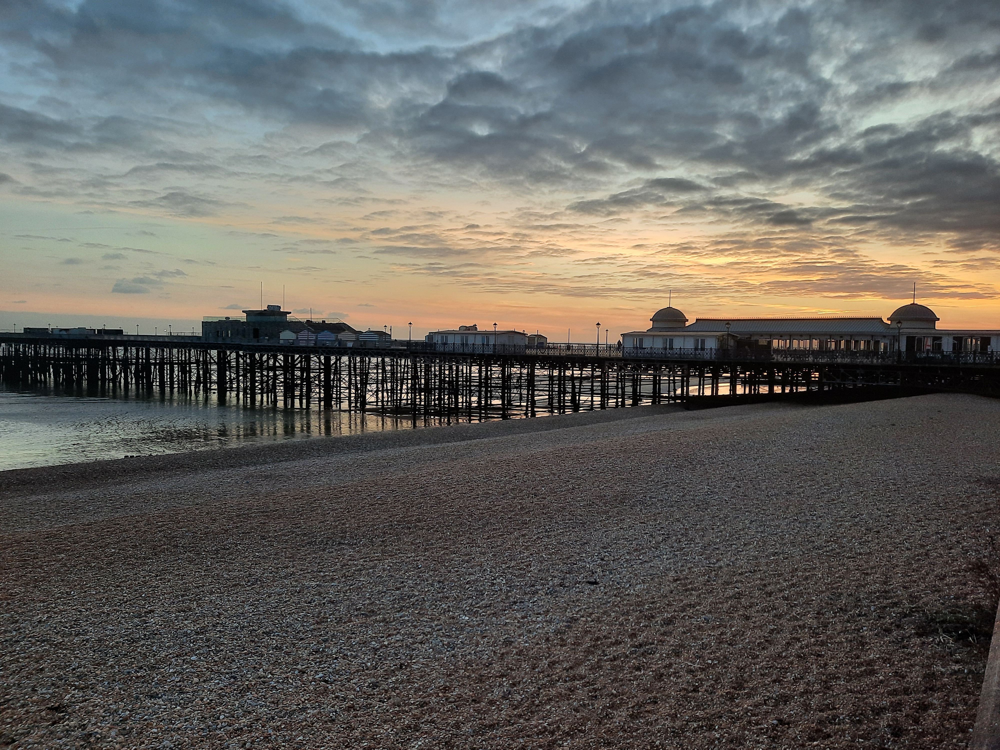
It was a short walk along the sea front to the Pier where I decided I would finish today. It was just a short walk, uphill unfortunately, to the station and short wait for a train direct to Brighton. It was just turning dark and I had timed this first leg to perfection. I would recommend it as a walk, it has many excellent elements and it is just hard enough!


And before I forget, I have added a “Subscribe” button to my ABOUT page (which needs a complete revamp!) – then you just get an email with each new post – these are going to sporadic! Thanks for reading :)

To aid/add to your confusion, 1 mile = 80 cricket pitches 😅
LikeLiked by 1 person
The whole walk just under 1200 cricket ptitches (or cps) – much easier to visualise :)
LikeLike