I thought I would have company on this leg so I started to do some research to point out points of interest. I found this website dedicated to all things Greenwich Meridian. The map showing all the Meridian markers would have allowed me to have appeared as an expert! Alas Liz didn’t join me, however as a professional GIS user and (obviously) a massive fan of maps and navigation – the section on “WGS84 and The Greenwich Meridian” is fascinating. WGS84 is a projection trying to find the best way to represent the curved earth on a flat map. So while (most of us) know the earth is a sphere, the early assumption was that the earth was a perfect sphere (its not!) and the Meridian wasn’t fixed until 2015. I was amazed to learn that the OS maps use a projection from 1860s, so it’s no wonder I get lost a lot!
I started from Lewisham and was quickly out of the town centre and into very nice housing area. The houses on the walk up Lewisham Hill to Blackheath were very impressive and showed the importance of this area in olden times. I’ve never been to Blackheath before and the wide open space and views were superb. The main thing I noticed were all the church spires poking out of the skyline. I counted six from one point, but I’m sure some were hidden behind trees.


Just across the road was Greenwich Park, the home of the Royal Observatory and the point the line of zero longitude was based/named. Before getting to the Observatory I decided to make a detour to one of the points of interest I’d spotted on the website. It was a line painted across a tennis court, and looked better online than in real life. I got a bit lost after this and undertook to avoid any further deviations for other points. One benefit of getting lost was finding the toilets (earlier one were closed due to blockages), but these were open taking the 20p entry with contactless payment! There were plenty of tourists at the Royal Observatory and I was content just looking through the gate at the iron Meridian Line in the cobblestones. People were enjoying standing astride the line, unaware that the actual line is about 102 metres away, to the east. This was only fixed in 2015, but things like plate tectonics will continue to affect it. I think is the reason why big projects that I have worked on, like Elizabeth Line and Tideway Sewer, have their own coordinate systems as the main one for the earth seems a bit dodgy!


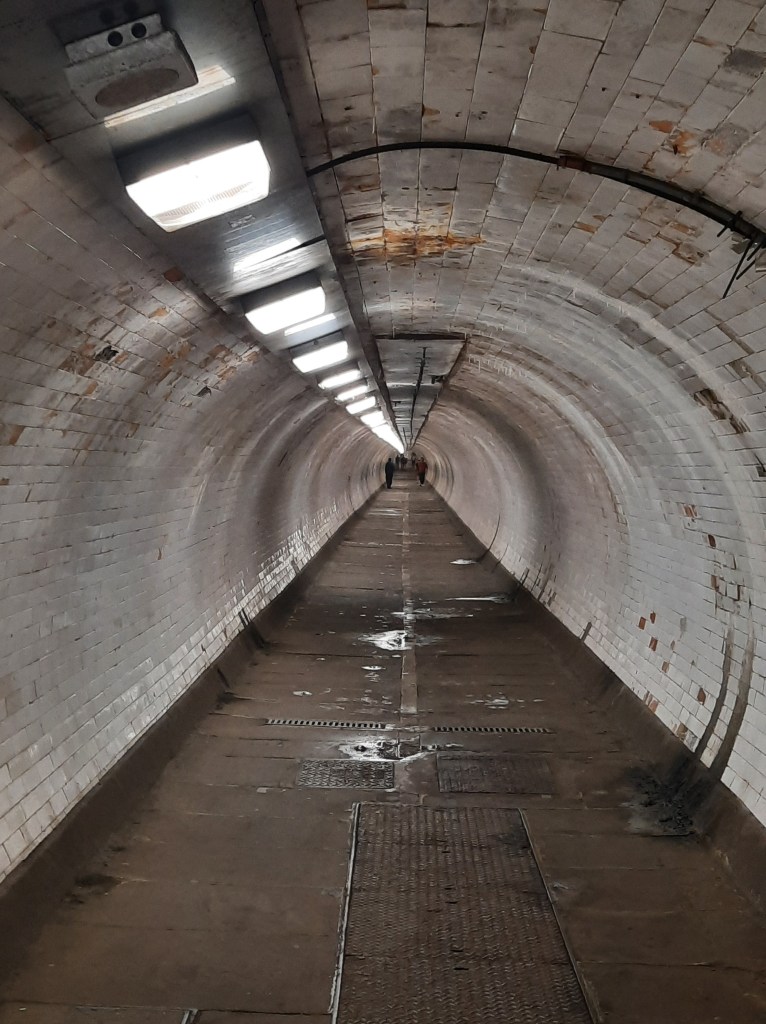
It was a nice downhill stroll to Greenwich and the Cutty Sark. It was nice and quiet, one of the advantages of walking on a Friday. It was beginning to heat up, and a second application of suncream was required, I think it was projected to be one of the hottest days of the year so far. Luckily, the sun can’t get you in the pedestrian tunnel under the Thames. I did the steps at both ends! The tunnel was built for pedestrians in 1901, and the short repaired section after a WW2 bomb is interesting.


The next section was following the Thames Path around the Isle of Dogs. It varied from along the river occasionally going along parallel streets. The river front was all new developments, while the back streets gave a glimpse of the history around the Millwall docks. The only consistent thing was walking on hot pavements, my feet were beginning to ache – I think trainers would have been better. After passing Canary Wharf, which has so many more buildings than when I worked there in the early 2010s. It seems to be constantly expanding with taller and taller buildings.


Not far from Canary Wharf, I left the Thames Path and joined a path alongside the Limehouse Cut. The Limehouse Cut essentially is what forms the Isle of Dogs to the south (this is what i initially thought, looking at the map I think the island is created by the docks cutting through the meandering river). I thought it was going to be a big channel as a short cut for big ships on the Thames, but it is a small canal letting barges get from the Lee Navigation canal into London without waiting for the tide on the lower Thames. It was built in 1770 for single traffic and later widened. The path stretched for quite a few kms and was a nice walk, interspersed with mild peril while passing people on the narrow path, if you got the water side. There was a lot of bird life, nesting coots, geese and in particular I saw a cormorant diving underwater at close quarters, the water was surprisingly clear.


The Limehouse Cut joined the Lee Navigation canal and the River Lee at a complicated set of locks. The river was much lower and I suspect boats can only get into the canal at high tide. White herons (egrets?) were fishing on the river and the whole parallel river arrangement became much more complicated when I got to the Tide Mills. These initially were for grinding flour, but were put to producing gin (somehow).


The views around this area were remarkable, and there was history everywhere. One particularly poignant thing was a memorial to people who had lost their lives trying to save others. The original monument was at the location of a manhole close by, where four men died in 1901, each trying to resuce the next before being overcome by hydrogen sulphide (or foul air as the monument calls it). I can remember confined spaces training videos in the 1980s showing this exact scenario.


The points of interest just kept coming and next up was the Greenway. The Greenway is actually the main Sewer network (Northern Outfall Sewer) serving the whole of North London built by Joseph Bazelgette in the 1860s. I got a good view of the huge pipes from under a bridge, and then from the top of the Greenway, a good view of Abbey Mills Sewage Pumping Station (or should that be “Palace”!). Its the most amazing building and was built to house beam engines to pump the sewage from the lower parts north of the Thames into the big sewers. I’ve been inside Crossness Pumping Station serving South London and it is just as beautifully decorated inside.


There was just too much to see, and around the next corner was Stratford, with busy transport hub, Westfield shopping centre and the Olympic Park. I quickly nipped into a smaller shopping centre for their facilities and a sandwich, loads of drinks and kept going. It has been hot and seemed to be getting hotter! There was a long road section next which was a bit boring, and I felt I was being eyed up for my phone a few times! Maybe I wasn’t, but I was being vigilant! After crossing under a rail bridge, I hit a nice common with pond, it was a relief to get off the road. This was the start of Epping Forest and I would follow a series of commons and woods to today’s destination which was Chingford. In fact they seemed to follow the River Ching, which is probably where the name came from (Wikipedia has other ideas – its an interesting read!).


The walk to Chingford represents over a third of the whole distance, but compared to the earlier excitement was relatively boring, so I don’t feel the urge to write much. With the heat of the day, the wooded and shady bits were particularly welcome, although there were a few navigation problems where (I’m pretty sure) the Ordnance Survey maps were wrong. I think the surveying quality is lower in Essex! There were a couple of lovely lakes, I had my late lunch and siesta under the trees at the one at Whipps Cross. This was also the first GMT trail marker I’d seen all day. The only other thing is a grumble, my feet were sore and the hard baked paths, with imprints or memory of a muddy quagmire were painful to walk on.


Eventually I reached Queen Elizabeth’s Hunting Lodge, very close to Chingford. From the map it looks like this is on the edge of Epping Forest proper. It was built in 1543 by Henry VIII, presumably for hunting in the forest. I’ll check out the forest on the next leg. Finally, I headed into Chingford. All I wanted was a corner shop for a cold bottle of coke. Instead, it is made up of wine bars, restaurants, and pubs lining the street with alfresco drinkers everywhere. It took a while to find a solitary Newsagents for provisions for the three trains I needed to get me home. A colleague, Neil, lives around these parts and commutes all the way to Epsom, I think I can see why – it’s a nice part of the world!

As if I haven’t typed enough, I feel compelled to write a bit about some of the pubs I’ve passed, and photographed ,on the way today. It started in Greenwich when I saw the Kings Arms a particularly appealing and well kept pub. Then, the Ferry Inn “the oldest pub on the island” on the Isle of Dogs, 1722, still with an old Courage sign. I also passed the Cart and Horses in Stratford that professes to be “the birthplace of Iron Maiden”. With it being reported that so many pubs have been closing recently, it was nice to see one still serving a community function as a mosque/community centre. It was the busiest “pub” I saw, but it was Friday prayers, and I suspect only has a limited number of ales available ;) . I would have loved to stop for a beer today, but think with the heat, it would have been too tempting to stay longer and I may not have made the train home!


Well that was a monster blog! I’ll stop writing now. I’m not sure when I will fit the next leg in. It maybe after the trek this is training for. The next will be a two day walk to Royston, with hopefully bed and breakfast in a pub half way, to make up for my lack of beer today.


PS: This was the first full blog post I have written on my phone since WordPress introduced the Jetpack app. I’m gradually getting used to it, with the photos linked through to Flickr. Please excuse any typos a life is a bit to short to go through everything! The speller checker get a bit enthusiastic, guessing something completely different, making up works or just ignoring basic spelling!

Did the sight of puddles on the floor of the tunnel under the Thames make you walk faster??
LikeLike
Yes – but not because of leaks, it reminded me that there are no (fewer) trees on these urban sections. You need to visit a pub for a wee, and feel compelled to have a pint, it’s a viscous circle!!!!
LikeLike
Enjoyed reading about your ride from Lewisham to Chingford. It’s fascinating how cycling can give you such a unique perspective on the city’s changing landscapes and communities. I’ll be looking for similar routes to explore myself!
LikeLike