With my love of long distance cycling, the current state of the world and finding myself perfectly located between the letters “C” and the “O” of the mammoth undertaking (by ThighsOfSteel. com) of writing “Refugees Welcome” across the south coast (what a brilliant idea!!) in GPS tracks.
A group rode the whole thing but they encouraged solo rides of individual letters. So I attempted the “C” at 127km (1,200m climbing) and then the “O” at 151km (1,800m climbing) – in total 178miles.
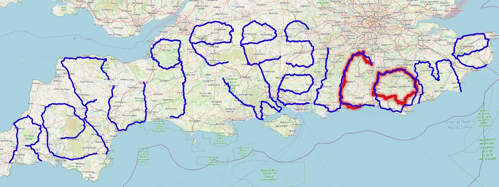
As an update ThighsOfSteel smashed the GPS drawing, World Record at 2,203km – and 169 riders took part raising over £81,000. So thanks to everyone who supported them/me. I’m most impressed with the feedback and the level of detail on where the money is going. You can clearly see how the money we raised can help these small organisations, it makes it even more worthwhile. Have a read here…..
https://www.thighsofsteel.com/reason.html
Onto the trip. Well…. as a regular reader, I’m sure you are aware – none of my trips ever start smoothly and this was no exception. Two weeks before my planned date I thought I should do some training (as I haven’t ridden since the summer) on my only working bike – which was my Airnimal folding bike. This was last used in 2016 in Perth (Scotland) where it broke four days after leaving John O’Groats and has been in mothballs since being repaired. A few weeks before the planned date, I headed off on a training ride, only for one of my pedals to become looser and looser. As I rode, it gradually stripped its thread in the crank arm. No amount of tightening would get me home before it completely wrecked the crank. Anyway with the international shortage of bicycle parts (due to Covid, Brexit & Suez) and not being able to get it repaired quickly, I had to buy something similar on ebay. A chainwheel with a few teeth less but just about fitted without too much fuss. So I headed off on one of the longest rides I’ve attempted, with no training, gearing that was a bit too low, and frequently only two of the three chain wheels being available. All minor issues, it should be fine!
The starting point of the “C” was Gatwick Airport, which was an easy train ride from home. The airport was deserted and certainly hasn’t fully recovered from the pandemic yet!

The “official” route took me to (up) Boxhill along a lot of roads I knew quite well including Pebblecoombe Hill. I haven’t tried to cycle up Pebblecoombe for many years and I can’t recall ever cycling all the way up, and I still can’t! I had a very welcome stop at the National Trust tearooms at the top, with only a few friday cyclists out, I’m sure this would be jammed at the weekends. From Boxhill it was a really nice route down the famous zig-zags to Dorking and a long climb up onto Ranmore Common which was a challenge. Although as always, after every climb there was the lovely long descent down into Abinger Hammer. I cycled past a pub called The Volunteer pub. This brought back memories, as it used to be a pub we would drive out to from South London on a sunday evening for a drink. It was a real surprise seeing it especially as I have no real idea where I was. How did we ever find it back in the 80’s hidden down country lanes?


While the route of the “C” was available to download, I had real trouble getting the GPX (navigation) file loaded onto my Beeline GPS, I think due to the number of data points. My Beeline is a great device with just a simple arrow which shows me the way on my handlebars – just right, not too intrusive and not too much information. However, this meant, I had to do a bit of mix and match, navigating between known points rather than religiously sticking to the “official” route. It was around this time I started to deviate slightly from the planned route. This included a muddy bridleway, so these definitely weren’t short cuts (honest!). I had intentionally taken a different route from Gatwick to Boxhill to ride along nicer lanes rather than on more urban roads and cycle lanes, but this was more random route planning.


Around this time the National Trust cake was beginning to wear off and I was ready for a stop. There weren’t many shops on the route and I was trying to avoid faffing around by not deviating of the route to find them. It seems to me that most of the local shops have turned into Beauty Salons or Hairdressers, probably the only services Amazon can’t bring to your door. It is worth reporting that a high proportion of vehicles are mysterious white delivery vans or supermarket delivery trucks, always parked on a dodgy corner, or chasing you down narrow roads with no passing place. Luckily pubs still exist and still sell snacks, so a nice stop in Loxwood for a shandy together with a crisp & peanut based lunch.

I knew the route went through Bury (on the A29), and the only thing I know is the infamous Bury Hill, which even used to be a challenge to cars in olden times (even the 1970’s). Initially I though the route had found a magical downhill route all the way around the hill, but this was soon dispelled. Reality hit on the hard climb up from Storrington. I built up quite a queue behind me on some stretches, but pulled over when opportunity allowed. There did seem to be a lot of vintage cars out and sometimes they were holding me up (on the flatter bits!). From the big roundabout at the top it was downhill to Arundel, and onto the coast.

It had been a hard ride, and (as normal) I hadn’t eaten enough all day, so was getting slower and slower! I had a bit of a Co-op sandwich feast on the beach which helped a lot. My destination was Hove Station and I headed along the coast into a light headwind until eventually the easy cycleways, the daylight and my energy started to disappear. I made it to Lancing Station, probably about 15km short – but its is still a discernible “C”. In fact it would have been quicker to cycle on further as the train I planned to catch, ultimately had a 58 minute delay leaving me hanging around the station for over an hour.


The next day, the starting point of the “O” was easy, as looking at the GPS tracks of the “Thighs of Steel” cyclists – they had gone within 30 metres of my house a few days earlier, so I could just leave from home. Using the “LightBox” (created by Liz) as the definitive Burgess Hill landmark as the start. I headed off into what can only be called hills, hills, hills! Despite the hills, the weather was amazing for September, really warm and nice and sunny. I was planning on doing the “O” in two days, with the northern part today and the shorter southern part tomorrow, when the weather was forecast to be worse.


I headed north up to the North Downs (because the hills are bigger there), and learnt my lesson from yesterday and I ate loads of sandwiches at Forest Row, after riding through the Ashdown Forest. From Forest Row the route headed south (ish – in a O shape) through some lovely countryside and villages in an area I hadn’t really explored before. Frant was very interesting, in addition to it being at the top of a big hill, with its village green with a WW2 pillbox proudly in the middle of it.

Somewhere around this point, I made a couple navigational errors including a potential disastrous confusion between Penshurst and Penhurst. With Penshurst, Kent 10 miles to the north, the wrong way and Penhurst, Sussex 20 miles to the south the right way, one of them should change their name! The other error was setting my satnav to head towards Polegate Station where I would finish the day. On the map it looks like I cut a corner off, however I’m sure it was a harder route with constant hills, while any minute I was expecting to drop down onto the Pevensey “levels” around Eastbourne and the Cinque Ports. The proper route headed south onto the flatter ground. Only when I got home did I see how many extra hills I added unnecessarily!

So for the last day, only a short section was left from Polegate to Burgess Hill. The official route went over the South Downs, on some busy roads along the coast and through Brighton, before heading over Ditchling Beacon (the easy way). It is worth saying at this point, I was riding the “O” in the reverse direction than the main group rode it, which would have been up Ditchling. I rode it this way as it was much better for rail connections and weather conditions. As it was just a short distance, Liz came along for the ride and therefore I planned a quieter route staying just north of the Downs. This would prove to be a very wise decision!

The weather had changed, and it was drizzling all day, with odd bits of heavier rain – but never really needing a waterproof – so all very pleasant. The (my) route followed the NCN 2 from Polegate, which includes some off-road tracks, we let some mountain bikers past at one point, but it was fine on narrow road tyres. We soon hit the quiet country lanes with a few “chain gangs” of cyclists punishing themselves, however we stopped to reward ourselves with a slightly bedraggled coffee in a pub in Laughton.


Soon we got to Lewes in time for lunch in The John Harvey Tavern – no epic ride is complete without a visit. It being both the virtual start, and actual end point of the South Downs Way in 2019. While I headed off to complete the last bit of the “O”, Liz was going to jump on the train home to avoid some of the busier roads. However, it was the London to Brighton Bike Ride, and no bikes were being allowed on the trains!! It took a bit of subterfuge but she eventually got on a train for long enough to be close to home. She wouldn’t have stood a chance from Brighton!

I easily made it home, just picking up a slow puncture as I passed the bottom of Ditchling Beacon, which was closed for the London to Brighton cycle ride (I would never have been allowed to cycle down it), with a few police and marshals just waiting for the last stragglers. I saw one cyclist walking towards the bottom of the hill – they must have have had a long day out! I didn’t fix the puncture in the rain, but had to stop twice to put air in the tyre and before I knew it….. I was home. An excellent 3 days, and thank you to my supporters we raised £500 towards a total over £80k for Thighs for Steel. Thank you :)

[Official Letter “C” 127km – 1185m climbing] Day 1 – 113km with 1185 m climbing
[Official Letter “O” 153km – 1740m climbing] Day 2 – 97km with 1352m climbing, Day 3 – 57km 388m climbing
